")


Hiking to Kvalvika
 Medium
 Moskenesøya
 5 hrs
5 hrs 10.09 km
 500 m
500 m 551 m
551 m Vest-Lofoten
 Until may on the pass
- Type of hike : Loop
- Visibility of the route : Good
- Start/Finish : Approximately 2 km after the village of Fredvang on the 986 road to Selfjord and Krystad, leave your car in the car-park between the road and the fjord opposite the starting- point of the hike (long: 13° 7" 58" - lat: 68° 4" 20"). The route starts on the other side of the ditch just opposite the car park.
- GPS Point : Start/finish: N68 04.097 E13 07.796
Kvalvika beach: N68 04.652 E13 05.788
Mountain hut above Fredvang: N68 04.979 E13 07.519 - Extensions : Climbing to Ryten, medium; 5 hrs; 10 km; ± 790 m, max altitude 540 m
Description
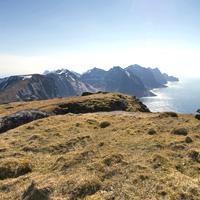
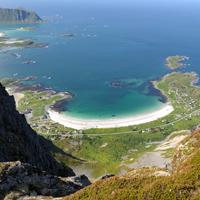
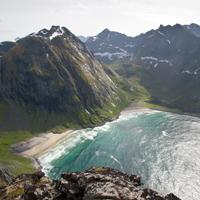
This famous route on the Lofoten islands takes you to an impressive beach flanked by dark granite cliffs and overlooking the Norwegian Sea.
More information about this hike...
|

Accessibility
 Yes
Yes Yes
Yes No
No Slideshow

View the embedded image gallery online at:
https://www.rando-lofoten.net/index.php/en/fredvang-kvalvika-en#sigProId056ed78337
https://www.rando-lofoten.net/index.php/en/fredvang-kvalvika-en#sigProId056ed78337
Video


Download the route | Kvalvika.gpx |
Join the start of the hike with Google Maps
You can use your actual location or enter the name of the place from which you wish to start