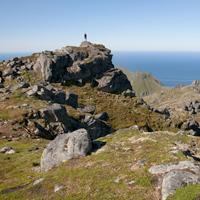
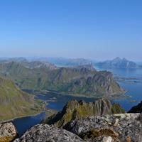
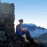
When you leave the island of Vestvågøy to go south of the Lofoten Islands, you see the summit of Stornapptinden rising up like a solitary impressive sentry facing the Straits of Nappstraumen.
More information about this hike...
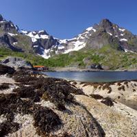
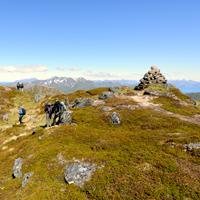
Hiking to Store Klauva
This magnificent hike is a good way of discovering the north-eastern part of the island of Flakstadøya between the fjord of Flakstadpollen and the Straits of Nappsstraumen. The trip starts in the little village of Napp at the car park near the jetty on the southern side of the port.
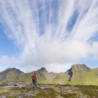
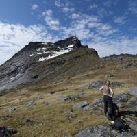
From here you take the little path, turning just after the stream on the right and head for the summits. Aim for the first summit, Litldalen (394 m), from which you already get a good view of the valley and the Straits. To the south-west you will see the tiny Lake Rennevatnet, which you should aim for. When you reach the lake, head south-east which will take you more or less around the south-eastern foot of Stor Klauva before climbing the steep slope to the top. From the top of Store Klauva you will see a long succession of summits and ridges, some of them very sharp, with spectacular views over the island of Flakstadøya. There are a few tricky sections where you will need a good head for heights as you tackle the steep slopes that take you to Handopshesten. You can reach the top of Handopshesten by climbing a very steep slope on the south-west side. The view from the top is worth all the effort! You then take the pass between Hestmanken and Hestraeva before following the left-hand side (north) of the valley of Sørdalen but without actually going down into the valley. You go down to the Straits of Nappsstraumen via a small valley (after point 212 on the map) which opens out into a place known as Andopen which only contains a few scattered farms in heavenly settings. You then follow the coastal path (red waymarkers) to Napp.
This is an excellent one-day hike to be tackled when the weather is fine. The summit is reached via a long line of peaks from which the views are as plentiful as they are magnificent.
More information about this hike...
Leaving Reine you take the little boat that acts as a shuttle between Reine and the various villages at the end of the fjord. Once the boat drops you off at Kjerkfjord, which is at the end of the fjord but feels like the ends of the earth, you can start one of the wildest hikes in the islands.
More information about this hike...
This majestic peak is in the northern part of the island of Flakstadoya from which there is an u uninterrupted view over the Norwegian Sea and the entire island. The hike offers a variety of landscapes including peatland, peaks, craggy mountain tops, and lakes, and crossespasses through the picturesque hamlet of Vikten with its golden -sand beach.
More information about this hike...
The top of Volandstinden is one of those peaks which, when seen from the road, seems totally inaccessible to hikers. It is, however, easy to climb without any particular difficulty. The steep peak also means it has a unique view over the island of Flakstadoya and bay of Ramberg.
More information about this hike...
This easy hike takes you to two nearby peaks that have very different views over the island of Austvagoya. The north-facing top of Kleppstadheia has a fine view over Gimsoystraumen (the stretch of sea that separates Austvagoya and Gimsoya) and the bay of Sydalspollen. The south-facing top of Kvasstinden, which is slightly higher, overlooks the magnificent narrow fjord of Olderfjorden.
The trail is clearly marked from the start and there is little risk of getting lost. The trail initially goes along the right slope of the mountain before heading north approximately half way up.
Once you have crossed a wooded area you reach open heathland. Head towards the first top of Kleppstadheia. Then to reach the top of Kvasstinden, hike along the ridge southwards and then from the east you cross a pass and climb towards the top of Kvasstinden that offers a superb viewpoint over one of the wildest valleys in the Lofoten Islands. Head back along the same path.
This beautiful isolated mountain range stands to the north-west of the island of Vestvågøya, a little off the main E10 road. Hikers here are few and far between despite the fact that the area is very beautiful and offers a wide range of panoramic views. The hike is possible either as a return trip or in a loop returning via the north shore of Lake Dalvatnet.
More information about this hike...
The top of Kartstaven, which is only 544m altitude, is in the centre of the island of Vestvagoya and offers a direct view over Vestfjord, which extends from the narrow Kartfjord. This hike is relatively easy and the trail is clearly marked if you choose to make a return trip.
More information about this hike...
Kabelvag to Olderfjorden
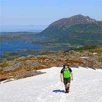
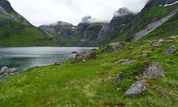
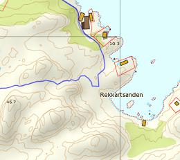
This hike takes you to the isolated fjord of Olderfjord and then to the island of Gimsoya crossing the mountains behind the village of Kabelvag. Other than at the start, the hike is over terrain without any trails whatsoever and is very wild, so don’t expect to meet many people after you leave the shores of Lake Stor-Kongsvatnet. On the other hand, you cross a landscape devoid of any sign of human life and when you go back down to the fjord you may well come across a lonely elk in the birch tree woods or in the middle of peatland. Don’t be surprised if your socks get wet!
On this particular hike we leave Kablevag on foot, then take the road to the school, then one of the trails (shown as red dots on the map) from Lake Stor-Kongsvatnet to Saeterbukta. From here we get back onto the trail that follows the lake to a sluice and a mini power plant (under the Dronningtinden peak). From here you “merely” have to follow the sluice along a steep path which may be dangerous when it rains because it is very slippery. Walk alongside the lake on your left (marked 133 on the map), then arrive near Lake Nokkvatnet (315). As it is not possible to walk along the shore of Lake Nokkvatnet, you will have to climb the embankment to the left of the lake to reach 400m altitude before moving onto the second lake, Vestre Nokkvatnet. Climb the embankment on your left behind Lake Vestre Nokkvatnet then go back down on the other side via the small flat section shown as point 270 on the map. From here head for the bottom of the valley and the peatland.
We don’t advise you to take the trail as indicated on the map but to hike along the shores of the fjord (Finnstranda, near the little wooden chalet). In order to do this, before you enter the peatland take a left turn towards the fjord, then when you get approximately 200m from the edge of the fjord, head for the north shore of the fjord and cross the river (by this stage you will probably no longer care about getting wet!). You will finally be on a real trail that extends the length of the right shore of the Olderfjord until it opens onto the Gimsoystraumen.
This small peak near Leknes on the peninsula of Offersøya is where a certain number of runners from the neighbouring town meet, you often see them jogging on the trail! Even though the altitude at the top is less than 450m, the panoramic view it offers is fantastic.
More information about this hike...
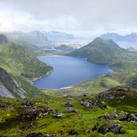
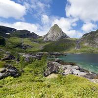
This beautiful hike will enable you to explore the most northern point of Moskenesoya Island, passing through wild, varied landscapes. From the top of the Litlberget ridge, which looks over the Stokkvikdalen valley, you can’t help thinking of the few families that lived there until the end of the nineteenth century in total isolation. From this recent past there now remain only a few foundations scattered around and peatland meadows enclosed by low stone walls. The magnificent Fuglhuken peak towers over the valley like a shield facing the Norwegian sea.
More information about this hike...
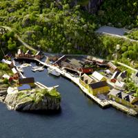
This hike is usually undertaken as a return trip. You can start either in the village of Nusfjord or the smaller village of Nesland. We recommend you start in Nesland because you get charged to go into Nusfjord when you come by road but entry is free when you arrive via the footpath ;-)
More information about this hike...
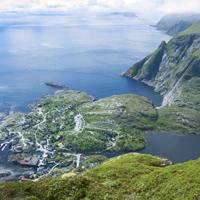
This peak, which is quite easy to climb for the Lofoten Islands, offers a fantastic view over the site of Nusfjord and its tiny fishing village. It also has an uninterrupted view of one of the finest coastlines in the islands…
More information about this hike...
A short half-day hike that includes a fine view over A i Lofoten and Lake Agvatnet. You need to take care nevertheless as this route is only for experienced hikers who know to only tackle it when the path is completely free of snow and who have a good head for heights. As you leave Sørvågen, take the path leading to Munkebu (Munkan).
At the first pass (long: 13° 0" 26" - lat: 67° 53" 50") take the left-hand path and take the little wooden bridge over the outlet of Lake Stuvdalsvatnet. Follow the path that goes up a fairly broad ridge where you will find a number of tiny lakes.
When you reach the end of the ridge turn left into the valley heading for the narrow pass on the right (the last few metres before the pass are steep). At the pass you will see a little path on the left which takes you to the summit. Return taking the same route.
A short hike in a heavenly setting overlooking the sea! There are no special difficulties about this hike which takes you up the majestic solitary peak that overlooks the tiny settlement of Hovsund.
More information about this hike...
Although these two beautiful peaks above the town of Leknes (Vestvagoya) are easy to climb, they offer a spectacular panorama of the central part of the Lofoten Islands.
More information about this hike...
This hike takes you from one side of the island of Austvågøya to the other via a fine range of mountains.
More information about this hike...
This magnificent hike runs along the ridges that overlook the plain of Leknes to the north and the majestic Vestfjord to the south. Throughout the hike you will be treated to a series of breathtaking views.
More information about this hike...
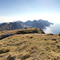
This hike provides the finest view over Reine fjord for those prepared to make the effort to reach the top. It follows the same route on the return journey and there is no trail at all on the second part.
More information about this hike...

")