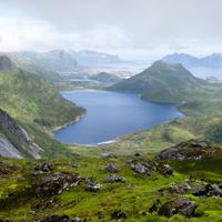
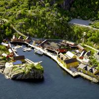
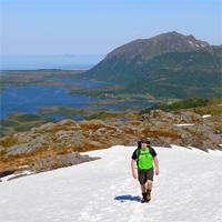
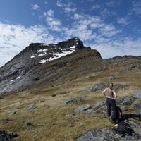
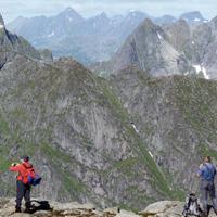
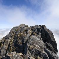
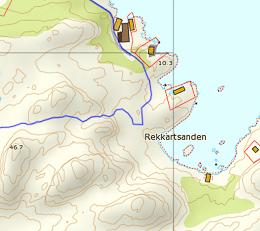
Kabelvag to Olderfjorden

Olderfjorden1


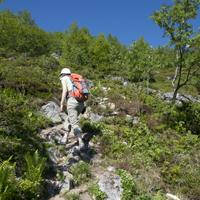
This hike takes you to the isolated fjord of Olderfjord and then to the island of Gimsoya crossing the mountains behind the village of Kabelvag. Other than at the start, the hike is over terrain without any trails whatsoever and is very wild, so don’t expect to meet many people after you leave the shores of Lake Stor-Kongsvatnet. On the other hand, you cross a landscape devoid of any sign of human life and when you go back down to the fjord you may well come across a lonely elk in the birch tree woods or in the middle of peatland. Don’t be surprised if your socks get wet!

On this particular hike we leave Kablevag on foot, then take the road to the school, then one of the trails (shown as red dots on the map) from Lake Stor-Kongsvatnet to Saeterbukta. From here we get back onto the trail that follows the lake to a sluice and a mini power plant (under the Dronningtinden peak). From here you “merely” have to follow the sluice along a steep path which may be dangerous when it rains because it is very slippery. Walk alongside the lake on your left (marked 133 on the map), then arrive near Lake Nokkvatnet (315). As it is not possible to walk along the shore of Lake Nokkvatnet, you will have to climb the embankment to the left of the lake to reach 400m altitude before moving onto the second lake, Vestre Nokkvatnet. Climb the embankment on your left behind Lake Vestre Nokkvatnet then go back down on the other side via the small flat section shown as point 270 on the map. From here head for the bottom of the valley and the peatland.

We don’t advise you to take the trail as indicated on the map but to hike along the shores of the fjord (Finnstranda, near the little wooden chalet). In order to do this, before you enter the peatland take a left turn towards the fjord, then when you get approximately 200m from the edge of the fjord, head for the north shore of the fjord and cross the river (by this stage you will probably no longer care about getting wet!). You will finally be on a real trail that extends the length of the right shore of the Olderfjord until it opens onto the Gimsoystraumen.

Hiking to Offersoykammen

Offersoyakammen3


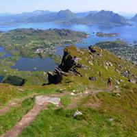
This small peak near Leknes on the peninsula of Offersøya is where a certain number of runners from the neighbouring town meet, you often see them jogging on the trail! Even though the altitude at the top is less than 450m, the panoramic view it offers is fantastic.


More information about this hike...

Cover EN ptYou can read the detailed description of this hike (as well as 59 other hike descriptions), enjoy hundreds of photos, maps and practical information on the paper guidebook Hiking the LOFOTEN ISLANDS.
You'll find the guidebook on logo amazon en, as well as at the following bookstores, for 24,07£ (not including shipping).

Order on Amazon

Hiking to Fuglhuken

On the top of Fuglhuken


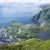
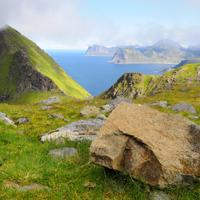
This beautiful hike will enable you to explore the most northern point of Moskenesoya Island, passing through wild, varied landscapes.  From the top of the Litlberget ridge, which looks over the Stokkvikdalen valley, you can’t help thinking of the few families that lived there until the end of the nineteenth century in total isolation. From this recent past there now remain only a few foundations scattered around and peatland meadows enclosed by low stone walls. The magnificent Fuglhuken peak towers over the valley like a shield facing the Norwegian sea.


More information about this hike...

Cover EN ptYou can read the detailed description of this hike (as well as 59 other hike descriptions), enjoy hundreds of photos, maps and practical information on the paper guidebook Hiking the LOFOTEN ISLANDS.
You'll find the guidebook on logo amazon en, as well as at the following bookstores, for 24,07£ (not including shipping).

Order on Amazon

From Nesland to Nusfjord

Close to Nusfjord - Lofoten


This hike is usually undertaken as a return trip. You can start either in the village of Nusfjord or the smaller village of Nesland. We recommend you start in Nesland because you get charged to go into Nusfjord when you come by road but entry is free when you arrive via the footpath ;-)


More information about this hike...

Cover EN ptYou can read the detailed description of this hike (as well as 59 other hike descriptions), enjoy hundreds of photos, maps and practical information on the paper guidebook Hiking the LOFOTEN ISLANDS.
You'll find the guidebook on logo amazon en, as well as at the following bookstores, for 24,07£ (not including shipping).

Order on Amazon

Hiking to Nesheia

Nusfjord (Lofoten)


This peak, which is quite easy to climb for the Lofoten Islands, offers a fantastic view over the site of Nusfjord and its tiny fishing village. It also has an uninterrupted view of one of the finest coastlines in the islands…


More information about this hike...

Cover EN ptYou can read the detailed description of this hike (as well as 59 other hike descriptions), enjoy hundreds of photos, maps and practical information on the paper guidebook Hiking the LOFOTEN ISLANDS.
You'll find the guidebook on logo amazon en, as well as at the following bookstores, for 24,07£ (not including shipping).

Order on Amazon

Hiking to Tindstinden

A i Lofoten seen from Tindstinden - Lofoten


A short half-day hike that includes a fine view over A i Lofoten and Lake Agvatnet. You need to take care nevertheless as this route is only for experienced hikers who know to only tackle it when the path is completely free of snow and who have a good head for heights. As you leave Sørvågen, take the path leading to Munkebu (Munkan).

At the first pass (long: 13° 0" 26" - lat: 67° 53" 50") take the left-hand path and take the little wooden bridge over the outlet of Lake Stuvdalsvatnet. Follow the path that goes up a fairly broad ridge where you will find a number of tiny lakes.

When you reach the end of the ridge turn left into the valley heading for the narrow pass on the right (the last few metres before the pass are steep). At the pass you will see a little path on the left which takes you to the summit. Return taking the same route.

Hiking to Hoven

willow ptarmigan (Lofoten)


A short hike in a heavenly setting overlooking the sea! There are no special difficulties about this hike which takes you up the majestic solitary peak that overlooks the tiny settlement of Hovsund.


More information about this hike...

Cover EN ptYou can read the detailed description of this hike (as well as 59 other hike descriptions), enjoy hundreds of photos, maps and practical information on the paper guidebook Hiking the LOFOTEN ISLANDS.
You'll find the guidebook on logo amazon en, as well as at the following bookstores, for 24,07£ (not including shipping).

Order on Amazon

Hiking to Bulitinden and Guratinden

 Summit Guratinden - Lofoten

 
Although these two beautiful peaks above the town of Leknes (Vestvagoya) are easy to climb, they offer a spectacular panorama of the central part of the Lofoten Islands.


More information about this hike...

Cover EN ptYou can read the detailed description of this hike (as well as 59 other hike descriptions), enjoy hundreds of photos, maps and practical information on the paper guidebook Hiking the LOFOTEN ISLANDS.
You'll find the guidebook on logo amazon en, as well as at the following bookstores, for 24,07£ (not including shipping).

Order on Amazon

Hiking to Justadtinden

Vestford view from the top of Justadtinden (Lofoten)


This magnificent hike runs along the ridges that overlook the plain of Leknes to the north and the majestic Vestfjord to the south. Throughout the hike you will be treated to a series of breathtaking views.


More information about this hike...

Cover EN ptYou can read the detailed description of this hike (as well as 59 other hike descriptions), enjoy hundreds of photos, maps and practical information on the paper guidebook Hiking the LOFOTEN ISLANDS.
You'll find the guidebook on logo amazon en, as well as at the following bookstores, for 24,07£ (not including shipping).

Order on Amazon

Hiking to Helvete

Djupfjorden (Lofoten)


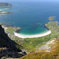
This hike provides the finest view over Reine fjord for those prepared to make the effort to reach the top. It follows the same route on the return journey and there is no trail at all on the second part.


More information about this hike...

Cover EN ptYou can read the detailed description of this hike (as well as 59 other hike descriptions), enjoy hundreds of photos, maps and practical information on the paper guidebook Hiking the LOFOTEN ISLANDS.
You'll find the guidebook on logo amazon en, as well as at the following bookstores, for 24,07£ (not including shipping).

Order on Amazon

Hiking to Hestræva

Delicious mushrooms from the Lofoten (Norway)


If you don’t look up as you drive along the E10 you can easily drive around the foot of this mountain without seeing the top. But it really is worth seeing!


More information about this hike...

Cover EN ptYou can read the detailed description of this hike (as well as 59 other hike descriptions), enjoy hundreds of photos, maps and practical information on the paper guidebook Hiking the LOFOTEN ISLANDS.
You'll find the guidebook on logo amazon en, as well as at the following bookstores, for 24,07£ (not including shipping).

Order on Amazon

Hiking to Himmeltindan

hiker writing her name on the guestbook at the top of Himmeltindan


A tough but enjoyable climb to the “Top of the Sky” (Himmeltindan). You can start from the beautiful beach of Haukland with its white sand and turquoise waves before climbing the old track that used to give access to the village of Utakleiv before the tunnel was built in the 20th century.


More information about this hike...

Cover EN ptYou can read the detailed description of this hike (as well as 59 other hike descriptions), enjoy hundreds of photos, maps and practical information on the paper guidebook Hiking the LOFOTEN ISLANDS.
You'll find the guidebook on logo amazon en, as well as at the following bookstores, for 24,07£ (not including shipping).

Order on Amazon

Hiking to Kitinden

kitinden-Lofoten


This fabulous peak offers outstanding views over Kvalvika beach and the mythical Ulvtinden summit. To reach it you cross a wide variety of landscapes ranging from heathland to rugged black granite rocks via small wild mountainous plateaus.


More information about this hike...

Cover EN ptYou can read the detailed description of this hike (as well as 59 other hike descriptions), enjoy hundreds of photos, maps and practical information on the paper guidebook Hiking the LOFOTEN ISLANDS.
You'll find the guidebook on logo amazon en, as well as at the following bookstores, for 24,07£ (not including shipping).

Order on Amazon

Hiking to Narvtinden

mushroom


For a long time looking at this peak from the E10 I imagined that it would be impossible to get to the top hiking without special equipment, but I was wrong since like most mountains in the Lofoten Islands it is possible, even fairly simple, to reach the top on foot…


More information about this hike...

Cover EN ptYou can read the detailed description of this hike (as well as 59 other hike descriptions), enjoy hundreds of photos, maps and practical information on the paper guidebook Hiking the LOFOTEN ISLANDS.
You'll find the guidebook on logo amazon en, as well as at the following bookstores, for 24,07£ (not including shipping).

Order on Amazon

Hiking to Moltinden (Flak)

Ramberg beach view from the path going to the top of Moltinden - Lofoten

 
This short, strenuous hike takes you from sea-level to an altitude of 700 m in approximately 2 km. The route is steep! The view from the top is extraordinary because it gives onto both the Norwegian Sea and the mountain peaks to the south of the islands.


More information about this hike...

Cover EN ptYou can read the detailed description of this hike (as well as 59 other hike descriptions), enjoy hundreds of photos, maps and practical information on the paper guidebook Hiking the LOFOTEN ISLANDS.
You'll find the guidebook on logo amazon en, as well as at the following bookstores, for 24,07£ (not including shipping).

Order on Amazon

Hiking to Moltinden (Mosk)

Eriophorum field (Lofoten)


You should be aware that several mountains in the Lofoten Islands have same name and more than one mountain  with the same name is on the same island! This particular Moltinden is above Kvalvika (Whale Beach) on the island of Moskenesøya. It is possible to do this hike as a return journey or a round trip if you are prepared to go “off-piste” on the second half of the route.


More information about this hike...

Cover EN ptYou can read the detailed description of this hike (as well as 59 other hike descriptions), enjoy hundreds of photos, maps and practical information on the paper guidebook Hiking the LOFOTEN ISLANDS.
You'll find the guidebook on logo amazon en, as well as at the following bookstores, for 24,07£ (not including shipping).

Order on Amazon

Hiking to Munkan

Rugged peaks seen from the summit of Munkan - Lofoten


When the weather is clear you get undoubtedly the best view of the south of the islands from the top of Munkan. This route is very popular with the inhabitants of the islands and, what is rare in the Lofoten Islands, there is a real path to the top.


More information about this hike...

Cover EN ptYou can read the detailed description of this hike (as well as 59 other hike descriptions), enjoy hundreds of photos, maps and practical information on the paper guidebook Hiking the LOFOTEN ISLANDS.
You'll find the guidebook on logo amazon en, as well as at the following bookstores, for 24,07£ (not including shipping).

Order on Amazon

Hiking to Slettheia

On the way to Slettheia


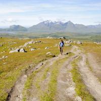
An easy hike that will enable you to explore the pastures of the Slettheia plateau which, despite a relatively low altitude, provides fabulous views over the turquoise-blue waters and bays below, as well as the plateau of Leknes and the various mountain ranges of the south of Vestvågøya Island. Perfect for children or half-day hikes.


More information about this hike...

Cover EN ptYou can read the detailed description of this hike (as well as 59 other hike descriptions), enjoy hundreds of photos, maps and practical information on the paper guidebook Hiking the LOFOTEN ISLANDS.
You'll find the guidebook on logo amazon en, as well as at the following bookstores, for 24,07£ (not including shipping).

Order on Amazon

From Myrland to Vikten

Myrland1


This hike begins in the isolated hamlet of Myrland (literally “peatland”) in the extreme north of the island of Flakstad and end in the village of Vikten via several valleys and a series of passes.


More information about this hike...

Cover EN ptYou can read the detailed description of this hike (as well as 59 other hike descriptions), enjoy hundreds of photos, maps and practical information on the paper guidebook Hiking the LOFOTEN ISLANDS.
You'll find the guidebook on logo amazon en, as well as at the following bookstores, for 24,07£ (not including shipping).

Order on Amazon

From Å i Lofoten to Stokkvika

Down to Stokkvika - Lofoten


This fabulous trip takes you from the east coast of Moskenes island across a steep pass to the west coast! Before you sign up for this hike remember that you will have to return via the same route. And don’t just judge the hike by the distance you travel; you need to be aware of the difficulty you may have in terms of the terrain you will be traversing.


More information about this hike...

Cover EN ptYou can read the detailed description of this hike (as well as 59 other hike descriptions), enjoy hundreds of photos, maps and practical information on the paper guidebook Hiking the LOFOTEN ISLANDS.
You'll find the guidebook on logo amazon en, as well as at the following bookstores, for 24,07£ (not including shipping).

Order on Amazon

Hiking to Ulvstinden

Ulvstinden1


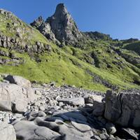
The Ulvstinden peak is one of the highest but least visited on the Island of  Moskenesøya. It rises majestically between Selfjord and the Norwegian Sea which is dominated by its steep cliffs. Even though there is no trail, two small cairns on the peak prove that a few hikers have already been here. The climb is tiring and you constantly have to be careful not to lose your way, but the view during the hike and once you get to the peak is well worth the effort.

After the car park continue on a path, then a trail that heads towards a peat bog at the bottom of the Stormarkdalen Valley. You will see opposite you a narrow valley that climbs from the plateau towards a pass between the Ryptinden peaks and the 563m point (shown on the map). When you arrive at the foot of the valley, walk along the right-hand side of the stream and climb alongside it for twenty metres or so through a wooded area. There isn’t a trail but despite a steep slope the hike is relatively easy. At around 200m you leave the wooded area and cross a grassy area interspersed with rocky slabs, then the slope becomes less steep and you spot the pass in a scree slope. Climb to the first pass from where you have a view over the wild bay of Hjelbergsvika (it is possible to go down via the valley to your left). From the pass climb the right slope (north east) to the 563m point. From here, head towards the south ridge of Ulvstinden and follow it until 640m altitude. Here you will see on your left (on the sea side) a relatively wide grassy verge that will take you down to 540m altitude in the valley at the foot of the west slope of the mountain. Once in the valley you will find yourself at the start of one of the hard climbs for which the Lofoten Islands are known (400m climb with an average 35° slope). Walk parallel to the ridge (on your right) while remaining approximately 150m from it. At around 820m altitude, climb straight ahead in the last stretch in order to reach the peak. Watch out, there are two peaks fifty metres or so apart. The first is accessible without any particular danger other than the 900m drop on the north face! The second peak, on which you can see a small cairn, must not be tackled under any circumstances without climbing equipment. You need to climb a 3m-high block, from which it is extremely tricky to get back down with a 900m drop on either side! Furthermore, the view from the second peak is no better than from the first. Go back down carefully the same way.

Hiking to Ballstadheia

Close of the top of Ballstadheia - Lofoten


This pleasant hike around the back of the village of Ballstadlandet takes you around the Vestfjord along a narrow coastal path before reaching a cape and then climbing back along a steep path up to the plateau of Ballstadheia.


More information about this hike...

Cover EN ptYou can read the detailed description of this hike (as well as 59 other hike descriptions), enjoy hundreds of photos, maps and practical information on the paper guidebook Hiking the LOFOTEN ISLANDS.
You'll find the guidebook on logo amazon en, as well as at the following bookstores, for 24,07£ (not including shipping).

Order on Amazon

Hiking to Brunakseltinden

Vinstad - Brunakseltinden


From the village of Vinstad, which can only be reached by boat, walk the length of the fjord along the village’s only street. At the end of the fjord take the trail on your left towards the Einangen pass.


More information about this hike...

Cover EN ptYou can read the detailed description of this hike (as well as 59 other hike descriptions), enjoy hundreds of photos, maps and practical information on the paper guidebook Hiking the LOFOTEN ISLANDS.
You'll find the guidebook on logo amazon en, as well as at the following bookstores, for 24,07£ (not including shipping).

Order on Amazon

Search the site ...

Advertisment

Planning your hiking trip to the Lofoten Islands?
Don't wait to be on site, and get them online at the "Maps Company", our official partner.

MapsCompany 400px 210x Maps Company is selling travel and hiking maps for all over the planet. The products are shiped within 24 hours, all over the world. They offer over 17,000 travel and hiking maps (over 200 countries).

To order hiking maps for the Lofotens, click here

Connection

In order to access certain services available on our site, (participation in forums, access to hiking sheets) you must register.

Boat Shuttle

Reine/Vindstad/Kjerkfjord

forsfjord vindstad

If you want to go from Forsfjord power station to Vindstad (or vice versa), and you don’t want to rely on the boat shuttle MS Fjordkyss, it is now possible to do it by foot.

We provide GPX track, map and the description (in french only) for the section connecting Vindstad to Forsfjord. This new possibility is particularly interesting for hikers engaged in the great crossing of the Lofoten Islands trek.

Our tips

Where to sleep, eat, drink and more in the Lofoten Islands

As we are not a tourist office, we will only publish recommandations for places we think are hikers and backpackers friendly and that we have tested AND appreciated. This section will get more stuff as we go along.

Who is online ?

We have 1347 guests and one member online

  • KeithBrose

Lofoten Webcams

Updated every 40min

North of the archipellago

Laukvik
Brotoy: E Raftsundet
Kabelvag: Ip kamera skistua, kongstind
Henningsvær - Austvågøya

Center of the archipellago

Steine: F Hagskaret (Retning Stamsund)
Ballstad: havn i Lofoten, Vestvågøy, Nordland

South of the archipellago

E10 Kåkernbrua - Moskenesøya
Vindstad: E Akkarvika

Latest news

 Visitor statistics

161,424 users, 24,000 subscribers and over 1,500,000 pages viewed in 2018!

To find out more about all the Rando-Lofoten visitor statistics with accurate data from Google Analytics, click here

 Increasingly accurate maps!

The Day Walks section has been improved thanks to the work of Frank Ingermann and the fantastic vector map background of Norgeskart.no (Norwegian Mapping Authority - Karverket). Hiking-Lofoten offers hiking guides that are getting ever more accurate and professional. Come and find out about them!

norgeskart-


Download the official Lofoten Islands maps

Lofoten Islands maps, scale 1:50 000 (UMT33)  download them for free on hiking-lofoten!Maps from the Norwegian National Institute of Cartography (Kartverket) are available in high definition (Tiff) on a set of ten maps.  Essential to prepare your hikes in the Lofoten Islands...

Lofoten maps

Northern lights forecast

Discover aurora forecast for Lofoten islands, thanks to NOAA POES satelitte from the "National Oceanic and Atmospheric Administration"

GPS routes

  • The GPS hiking routes are finally available as free downloads from the Hikes section!
  • Discover eight new routes in the Lofoten Islands with detailed Topos from Rando-Lofoten.

Day Length in the Lofoten

The Lofoten archipelago is located above the Arctic Circle, the result of this situation is a period of permanent days in summer and at the opposite a period of permanent night in winter (polar night).

To organize properly your trips and expedition in this region, it is important to take this phenomenon into account due to the high latitude. Discover our sunset/sunrise calendar

Copyright

Any representation whether total or partial of this site or content (general structure, texts, sound, logos, images whether animated or otherwise), by any method whatsoever, without the authors express prior approval is prohibited and constitutes infringement sanctioned by the Intellectual Property Code. The GPX tracks that can be downloaded on this website, bellong to hiking-lofoten and is for a private use only (not for commercial use). In order to reproduce the tracks in any form or on any medium (paper, digital, website, etc.), we ask you to mention the following (under or on the map): GPX track © hiking-lofoten.net