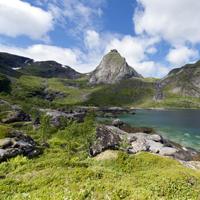
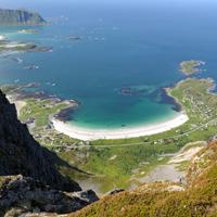
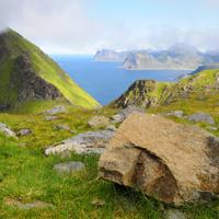
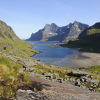
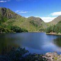
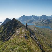
This hike provides the finest view over Reine fjord for those prepared to make the effort to reach the top. It follows the same route on the return journey and there is no trail at all on the second part.
More information about this hike...
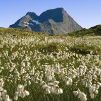
If you don’t look up as you drive along the E10 you can easily drive around the foot of this mountain without seeing the top. But it really is worth seeing!
More information about this hike...
A tough but enjoyable climb to the “Top of the Sky” (Himmeltindan). You can start from the beautiful beach of Haukland with its white sand and turquoise waves before climbing the old track that used to give access to the village of Utakleiv before the tunnel was built in the 20th century.
More information about this hike...
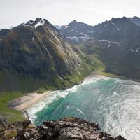
This fabulous peak offers outstanding views over Kvalvika beach and the mythical Ulvtinden summit. To reach it you cross a wide variety of landscapes ranging from heathland to rugged black granite rocks via small wild mountainous plateaus.
More information about this hike...
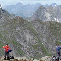
For a long time looking at this peak from the E10 I imagined that it would be impossible to get to the top hiking without special equipment, but I was wrong since like most mountains in the Lofoten Islands it is possible, even fairly simple, to reach the top on foot…
More information about this hike...
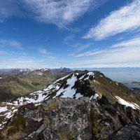
This short, strenuous hike takes you from sea-level to an altitude of 700 m in approximately 2 km. The route is steep! The view from the top is extraordinary because it gives onto both the Norwegian Sea and the mountain peaks to the south of the islands.
More information about this hike...
You should be aware that several mountains in the Lofoten Islands have same name and more than one mountain with the same name is on the same island! This particular Moltinden is above Kvalvika (Whale Beach) on the island of Moskenesøya. It is possible to do this hike as a return journey or a round trip if you are prepared to go “off-piste” on the second half of the route.
More information about this hike...
When the weather is clear you get undoubtedly the best view of the south of the islands from the top of Munkan. This route is very popular with the inhabitants of the islands and, what is rare in the Lofoten Islands, there is a real path to the top.
More information about this hike...
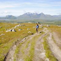
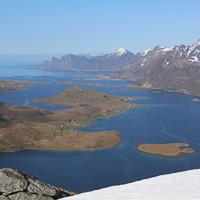
An easy hike that will enable you to explore the pastures of the Slettheia plateau which, despite a relatively low altitude, provides fabulous views over the turquoise-blue waters and bays below, as well as the plateau of Leknes and the various mountain ranges of the south of Vestvågøya Island. Perfect for children or half-day hikes.
More information about this hike...
This hike begins in the isolated hamlet of Myrland (literally “peatland”) in the extreme north of the island of Flakstad and end in the village of Vikten via several valleys and a series of passes.
More information about this hike...
This fabulous trip takes you from the east coast of Moskenes island across a steep pass to the west coast! Before you sign up for this hike remember that you will have to return via the same route. And don’t just judge the hike by the distance you travel; you need to be aware of the difficulty you may have in terms of the terrain you will be traversing.
More information about this hike...
Hiking to Ulvstinden
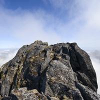
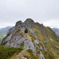
The Ulvstinden peak is one of the highest but least visited on the Island of Moskenesøya. It rises majestically between Selfjord and the Norwegian Sea which is dominated by its steep cliffs. Even though there is no trail, two small cairns on the peak prove that a few hikers have already been here. The climb is tiring and you constantly have to be careful not to lose your way, but the view during the hike and once you get to the peak is well worth the effort.
After the car park continue on a path, then a trail that heads towards a peat bog at the bottom of the Stormarkdalen Valley. You will see opposite you a narrow valley that climbs from the plateau towards a pass between the Ryptinden peaks and the 563m point (shown on the map). When you arrive at the foot of the valley, walk along the right-hand side of the stream and climb alongside it for twenty metres or so through a wooded area. There isn’t a trail but despite a steep slope the hike is relatively easy. At around 200m you leave the wooded area and cross a grassy area interspersed with rocky slabs, then the slope becomes less steep and you spot the pass in a scree slope. Climb to the first pass from where you have a view over the wild bay of Hjelbergsvika (it is possible to go down via the valley to your left). From the pass climb the right slope (north east) to the 563m point. From here, head towards the south ridge of Ulvstinden and follow it until 640m altitude. Here you will see on your left (on the sea side) a relatively wide grassy verge that will take you down to 540m altitude in the valley at the foot of the west slope of the mountain. Once in the valley you will find yourself at the start of one of the hard climbs for which the Lofoten Islands are known (400m climb with an average 35° slope). Walk parallel to the ridge (on your right) while remaining approximately 150m from it. At around 820m altitude, climb straight ahead in the last stretch in order to reach the peak. Watch out, there are two peaks fifty metres or so apart. The first is accessible without any particular danger other than the 900m drop on the north face! The second peak, on which you can see a small cairn, must not be tackled under any circumstances without climbing equipment. You need to climb a 3m-high block, from which it is extremely tricky to get back down with a 900m drop on either side! Furthermore, the view from the second peak is no better than from the first. Go back down carefully the same way.
This pleasant hike around the back of the village of Ballstadlandet takes you around the Vestfjord along a narrow coastal path before reaching a cape and then climbing back along a steep path up to the plateau of Ballstadheia.
More information about this hike...
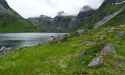
From the village of Vinstad, which can only be reached by boat, walk the length of the fjord along the village’s only street. At the end of the fjord take the trail on your left towards the Einangen pass.
More information about this hike...
Route proposed par Halfdan Holm
The start is the same as for the trip "Selfjord-Kjerkfjord", this means; at the end of the gravel road at Selfjord.
The begining is quite wet, but when you start gaining altitude, it gets dryer, though its probably too late. Turn towards the East just before the lake of Fageråvatnet. The path disapeares before you start with the real climbing. When you’re up on the ridge, and start walking towards Tverrfjellet, the magnificent Selfjord begins to show. Same way back.
Route proposed par hr.frosk
The trip up to Flakstatinden, or the "Gina's-Route" was inaugurated in 2013 by the Norwegian Queen to celabrate the 100 years anniversary of women’s voting rights in Norway. It was named after Gina Krog an activist from Flakstad fighting for the women's voting right.
It is therefore a very good and clear path. One of the best in Lofoten. It is a short and easy trip where you gain altitude fast, and is a little bit steep during the last hundred meters. Halfway up you find a nice small shelter. Return same way.
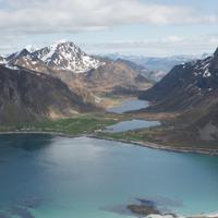
The summit of Blekktinden (622 m) rises majestically above the bay of Flakstadpollen on the Island of Flakstad. The climb is steep but includes no major difficulties apart from the track disappearing from time to time. From the summit the view over the island of Flakstadoy is magnificent. You come down along a ridge with a bird’s eye view of the neighbouring valleys.
More information about this hike...
A fine hike through a varied landscape. Leaving Ballstad, the path winds around a number of tiny lakes before taking you towards the valley of Kyllingdalen. You then walk through a pinewood straight out of “Hansel and Gretel”.
More information about this hike...
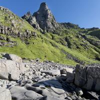
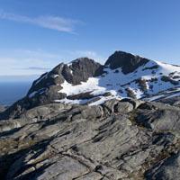
The Støvla peak (824m) majestically overlooks the small port of Sørvågen. With its amphitheatre-like rock formation backing onto a dark granite cliff it resembles a giant throne. The peak is surrounded by lakes and cliffs and appears inaccessible to hikers. If you ask the locals whether there is a trail to the peak, they will all give you different answers and be a little vague about which route to follow. There is to our knowledge only two tracks to climb to the top without climbing equipment. We chose to present you the passage crossing the mountain of Snaufjellet , which is longer but allows access to the top without waiting for it to be completely cleared of snow. This walk is long and complex, which explains why so few people bother.
There is a second path, by a rocky ledge on the east slope of the mountain (south of Lake Fjerddalsvatnet ) . Warning, this second path presents risks as long as the snow has not completely disappeared from the northern face of the mountain.
More information about this hike...
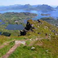
This large hill surrounded by water on either side is easily climbed due to its rounded shape and the good trail that crosses it. Even though the peak is not particularly high, it boasts an outstanding 360° view with the Leknes plateau and Buksnesfjord to the east and south, the Norwegian Sea to the west and, to the north, the impressive Himmeltindan mountain that towers almost 1000m above sea level. An easy hike that is great to do as a family.
More information about this hike...

")