")


Hiking to Finnkjerka
 Easy / Medium
 Vestvågøya
 3 hrs
3 hrs 10.08 km
 518 m
518 m 403 m
403 m Vestvågøy
 Until May on the top
- Type of hike : Loop
- Visibility of the route : The path is barely visible on the descent behind the Åland farm
- Start/Finish : In the first curve of the E10, just after a place called Straumgård, on the way up to the neck of Torvdalshalsen. The parking is marked on the map (close to a old abandoned building)
- GPS Point : Summit: N68° 04.309' E13° 17.995'
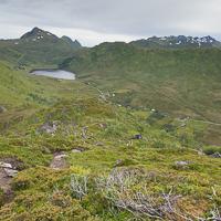
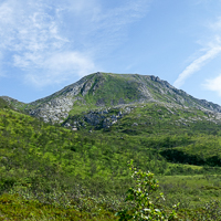
This relatively easy hike near the Lofotr Viking Museum in Borg includes a good trail over the entire distance, which is so unusual in the Lofoten islands that it needs to be emphasised. It climbs up the gigantic hill of Helfjellet to the north of the island of Vestvågøya.
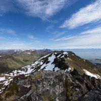
From the summit of Finnkjerka there is a fine viewpoint over the north of the islands. Weather permitting, and depending in how the mood takes you, you can either do this hike as a round trip climbing to the summit of Veten (414m), or in a loop hiking past Åland farm in which case you will have to go back along the trail to Straumgård. Lastly, by following the trail along the ridges, it’s possible to reach Vardheia (325m) where the Vikjorda-Brustranda hike and “The Great Crossing of the Lofoten islands” cross.
The trail leaves from the car park (marked as “P” on the map on the bend after Straumgård) and climbs the hill (marked 97 on the map). Shortly afterwards it heads left and climbs up a steep slope to the plateau of Helfjellet that you reach at an altitude of approximately 300 m. The trail then follows the straight edge of the plateau heading south-west. The plateau is covered with shrubs and you will see several trails that head off in different directions. It’s a good idea to walk to the end of Finnkjerka (392m) from where you have a different view of the summit of Veten. From here take one of the trails to the summit of Veten (414m). After Veten the trail goes down to a pass located above Åland farm. Between the pass and the farm the trail sometimes gets lost in the tall grasses (depending on the season). In Åland you will meet up with the trail that will take you back to your starting point. Helfjellet is an easy hike that gives you a fine viewpoint over the island of Austvågøya, and is a perfect hike for all the family.
 Yes
Yes Yes
Yes Yes
Yes
https://www.rando-lofoten.net/en/?Itemid=1180&option=com_content&lang=en-GB&view=article&id=505#sigProId2f7ba5f43c


Download the route |
Helfjellet.gpx |
Join the start of the hike with Google Maps
You can use your actual location or enter the name of the place from which you wish to start