")


Hiking to Kroktinden
 Medium
 Austvågøya
 3 to 4 hrs
 8.37 km
 655 m
655 m 671 m
671 m Vågan
Vågan until May at the top
- Type of hike : Go back
- Visibility of the route : good to avreage
- Start/Finish : Driving from Svolvær on E10, take Route 864, which leaves to the right just before the Gimsøystraumbrua bridge and serves the hamlets of Sydalen and Gravermarka. In Sydalen, take the little road to the right that goes to the back of the valley. After 1 kilometer (0.6 miles), the trail turns to the left and goes to a little cemetery (a green square on the 1/50,000 Vågan map). It is possible to park in the parking lot in front of the cemetery. From the lot you will find a track, closed to traffic by a raiseable gate, that leads to the end of the valley.
- GPS Point : Start/Finish : N68° 17.264' E14° 21.606'
End of dirt road and start of the trail : N68° 17.441' E14° 22.645'
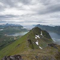
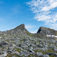
Summit : N68° 17.147' E14° 25.475' - Note : Kroktinden is a double summit, separated by a sharp, rocky ridge forming a pass. The hike described here leads to the first summit at 707 m (2,320 ft). The second summit, 754 m high, is no longer a hike but a climb for mountaineers.
Description
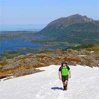
The Kroktinden summit, “the crooked summit” in Norwegian, looks like the tooth of a saw pointing to the sky. It’s a beautiful peak, relatively easy to reach, and offers a series of fantastic panoramas over the most mountainous island in the archipelago. Finally, not to diminish your pleasure in the slightest, a pretty little trail is visible all along the way and goes right to the summit.
Accessibility
 No
No Yes
Yes No
No
Slideshow

View the embedded image gallery online at:
https://www.rando-lofoten.net/en/?Itemid=1608&option=com_content&lang=en-GB&view=article&id=696#sigProIde83d9c370a
https://www.rando-lofoten.net/en/?Itemid=1608&option=com_content&lang=en-GB&view=article&id=696#sigProIde83d9c370a
Video


Download the route |
Kroktinden.gpx |
Join the start of the hike with Google Maps
You can use your actual location or enter the name of the place from which you wish to start