Hiking to Breidtinden

DifficultyMedium
LocationVestvågøya
Duration4 to 5 hrs
Distance9.92 km
Climb600 m
Maximum altitude449 m
Map - 1:50 000Vestvågøy
Snow riskUntil May on the summit
  • Type of hike : Go back
  • Visibility of the route : Good at the begining but poor at the end
  • Start/Finish : At the crossroads leading to Reineveien and Ballstadlandet (near the boat shop).
  • GPS Point : Start/finish: N68 04.489 E13 31.663
    Summit: N68 05.436 E13 29.228
Lake at the foot of Breidtinden - Lofoten
Description


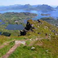
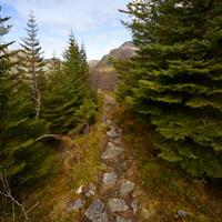
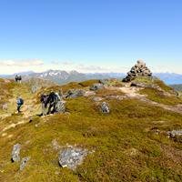
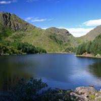
A fine hike through a varied landscape. Leaving Ballstad, the path winds around a number of tiny lakes before taking you towards the valley of Kyllingdalen. You then walk through a pinewood straight out of “Hansel and Gretel”.


More information about this hike...

Cover EN ptYou can read the detailed description of this hike (as well as 59 other hike descriptions), enjoy hundreds of photos, maps and practical information on the paper guidebook Hiking the LOFOTEN ISLANDS.
You'll find the guidebook on logo amazon en, as well as at the following bookstores, for 24,07£ (not including shipping).

Order on Amazon

Accessibility
Yes
Yes
No
Download the route
Breitinden.gpx

Join the start of the hike with Google Maps

You can use your actual location or enter the name of the place from which you wish to start

Other hikes nearby

Hiking to Ballstadheia

Hiking to Ballstadheia

Located at 0.6 km
Vestvågøya
DifficultéMedium
7.5 km

Accessibility
Yes
Yes
No
Hiking to Store Klauva

Hiking to Store Klauva

Located at 7.1 km
Flakstadøya
DifficultéDifficult
14.4 km

Accessibility
No
Yes
No
From Napp to Nusfjord

From Napp to Nusfjord

Located at 7.1 km
Flakstadøya
DifficultéMedium / Difficult
17.2 km

Accessibility
No
Yes
No
Hiking to Bulitinden and Guratinden

Hiking to Bulitinden and Guratinden

Located at 7.3 km
Vestvågøya
DifficultéMedium
9.9 km

Accessibility
Yes
Yes
No

Copyright

Any representation whether total or partial of this site or content (general structure, texts, sound, logos, images whether animated or otherwise), by any method whatsoever, without the authors express prior approval is prohibited and constitutes infringement sanctioned by the Intellectual Property Code. The GPX tracks that can be downloaded on this website, bellong to hiking-lofoten and is for a private use only (not for commercial use). In order to reproduce the tracks in any form or on any medium (paper, digital, website, etc.), we ask you to mention the following (under or on the map): GPX track © hiking-lofoten.net