")


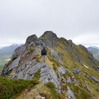
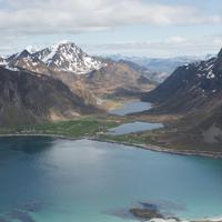
Hiking to Hestræva
 Easy / Medium
 Flakstadøya
 4 hrs
4 hrs 5.24 km
 520 m
520 m 499 m
499 m Vest-Lofoten
 Until June on the summit
- Type of hike : Go back
- Visibility of the route : Poor at beginning but improves
- Start/Finish : On the E10, approximately 500 m after the village of Kilen going towards Vareid. Leave your car in the little car park to the left of the road on the same side as the fjord. The path starts 150 m away towards Kilan.
- GPS Point : Start/finish: N68° 05.259' E13° 20.392'
Peak: N68° 05.130' E13° 22.865'

Description
If you don’t look up as you drive along the E10 you can easily drive around the foot of this mountain without seeing the top. But it really is worth seeing!
More information about this hike...
|

Accessibility
 Yes
Yes Yes
Yes Yes
Yes Slideshow

View the embedded image gallery online at:
https://www.rando-lofoten.net/en/?Itemid=767&option=com_content&lang=en-GB&view=article&id=197#sigProId1787967e21
https://www.rando-lofoten.net/en/?Itemid=767&option=com_content&lang=en-GB&view=article&id=197#sigProId1787967e21


Download the route | Hestraeva.gpx |
Join the start of the hike with Google Maps
You can use your actual location or enter the name of the place from which you wish to start