")


Hiking to Nesheia
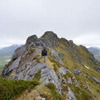
 Easy / Medium
 Flakstadøya
 3 to 4 hrs
 8.2 km
 665 m
665 m 408 m
408 m Vest-Lofoten
 Until June on the summit
- Type of hike : Go back
- Visibility of the route : Good to medium
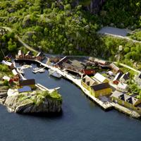
- Start/Finish : Parking 1km before Nusfjord just before the fish farm. Trailhead opposit to the parking (on the other side of the road)
- GPS Point : Start/finish: N68° 03.157' E13° 21.219'
Start of secondary path: N68° 03.470' E13° 20.866'
Nice view point over Nusfjord: N68° 02.257' E13° 21.862'
Summit: N68° 02.305' E13° 22.106'
Description
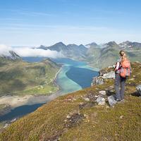
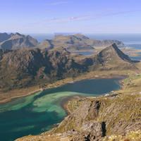
This peak, which is quite easy to climb for the Lofoten Islands, offers a fantastic view over the site of Nusfjord and its tiny fishing village. It also has an uninterrupted view of one of the finest coastlines in the islands…
More information about this hike...
|

Accessibility
 No
No No
No No
No Slideshow

View the embedded image gallery online at:
https://www.rando-lofoten.net/en/?Itemid=784&option=com_content&lang=en-GB&view=article&id=211#sigProId7736b85bbd
https://www.rando-lofoten.net/en/?Itemid=784&option=com_content&lang=en-GB&view=article&id=211#sigProId7736b85bbd


Download the route | Nesheia_Nusfjord.gpx |
Join the start of the hike with Google Maps
You can use your actual location or enter the name of the place from which you wish to start