Hiking to Fuglhuken

DifficultyMedium / Difficult
LocationMoskenesøya
Duration5 to 6 hrs
Distance11.29 km
Climb669 m
Maximum altitude564 m
Map - 1:50 000Vest-Lofoten
Snow riskUntil May on the summit
  • Type of hike : Loop
  • Visibility of the route : Good to poor (depending of the places)
  • Start/Finish : Car park at the end of the road to Yttersand. The trail leaves from the end of the Car park on the left (on the mountain side).
  • GPS Point : Start/Finish: N68 05.941 E13 08.087
    Summit: N68 06.274 E13 04.84
On the top of Fuglhuken
Description


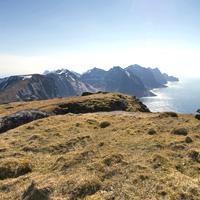
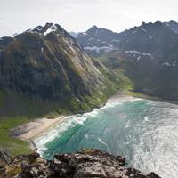
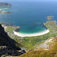
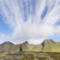
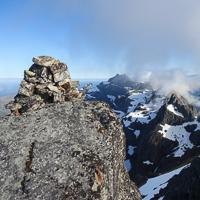
This beautiful hike will enable you to explore the most northern point of Moskenesoya Island, passing through wild, varied landscapes.  From the top of the Litlberget ridge, which looks over the Stokkvikdalen valley, you can’t help thinking of the few families that lived there until the end of the nineteenth century in total isolation. From this recent past there now remain only a few foundations scattered around and peatland meadows enclosed by low stone walls. The magnificent Fuglhuken peak towers over the valley like a shield facing the Norwegian sea.


More information about this hike...

Cover EN ptYou can read the detailed description of this hike (as well as 59 other hike descriptions), enjoy hundreds of photos, maps and practical information on the paper guidebook Hiking the LOFOTEN ISLANDS.
You'll find the guidebook on logo amazon en, as well as at the following bookstores, for 24,07£ (not including shipping).

Order on Amazon

Accessibility
No
Yes
No
Download the route
Fuglhuken.gpx

Join the start of the hike with Google Maps

You can use your actual location or enter the name of the place from which you wish to start

Other hikes nearby

Hiking to Kvalvika

Hiking to Kvalvika

Located at 1.2 km
Moskenesøya
DifficultéMedium
10.1 km

Accessibility
Yes
Yes
No
Hiking to Moltinden (Flak)

Hiking to Moltinden (Flak)

Located at 4.2 km
Flakstadøya
DifficultéMedium / Difficult
4.3 km

Accessibility
No
No
No
Hiking to Volandstinden

Hiking to Volandstinden

Located at 4.6 km
Flakstadøya
DifficultéMedium
6.4 km

Accessibility
No
Yes
No
Hiking to Stortinden

Hiking to Stortinden

Located at 5.0 km
Flakstadøya
DifficultéDifficult
5.4 km

Accessibility
No
No
No

Copyright

Any representation whether total or partial of this site or content (general structure, texts, sound, logos, images whether animated or otherwise), by any method whatsoever, without the authors express prior approval is prohibited and constitutes infringement sanctioned by the Intellectual Property Code. The GPX tracks that can be downloaded on this website, bellong to hiking-lofoten and is for a private use only (not for commercial use). In order to reproduce the tracks in any form or on any medium (paper, digital, website, etc.), we ask you to mention the following (under or on the map): GPX track © hiking-lofoten.net