")


Einangen to Mortsund
 Medium
 Vestvågøya
 3 hrs
3 hrs 4.8 km
 630 m
630 m 513 m
513 m Vest-Lofoten
 Until May at the summit
- Type of hike : Crossing
- Visibility of the route : Good to medium
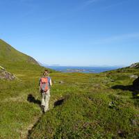
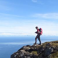
- Start/Finish : The trip can either start in Mortsund or at the Einangen pass, and you can park your car where the track starts in both ends. There is a clear path all the way, with only few difficult parts where you will have to sue your hands. The view is, as it always is in Lofoten, magnificent
- GPS Point : Start (Einangen pass) :N68 06.704 E13 40.314
Finish (Mortsund) : N68 05.052 E13 38.202
Summit of Ramntinden : N68 06.196 E13 40.504
Summit of Breidtinden : N68 05.938 E13 40.789
Summit of Middagstinden : N68 05.423 E13 39.582
Description
Track proposed by Halfdan Holm
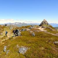
When you walk in Lofoten you often walk just straight up to the peak, and straight down again. Personally I love walking on ridges, and this is one of the few places in Lofoten where you can do exactly that.
More information about this hike...
|

Accessibility
 No
No No
No No
No Slideshow

View the embedded image gallery online at:
https://www.rando-lofoten.net/en/hiking-from-einangen-to-mortsund#sigProIdb9c7814c88
https://www.rando-lofoten.net/en/hiking-from-einangen-to-mortsund#sigProIdb9c7814c88


Download the route | Breidtinden-Mortsund.gpx |
Join the start of the hike with Google Maps
You can use your actual location or enter the name of the place from which you wish to start