")


Hiking to Hellostinden
 Easy / Medium
 Vestvågøya
 4 to 5 hrs
 8.53 km
 680 m
680 m 566 m
566 m Vestvågøy
 Until June at the summit
- Type of hike : Go back
- Visibility of the route : Good to medium or poor (in some places)
- Start/Finish : Coming from Svolvaer, keep on for 2 km (1.2 mi.) after the hamlet of Grundstad. In the middle of a big bend in the road, just after the place known as Lyngedal, you'll see an old wooden shed (formerly a garage) on your left. It is possible to park in front of this building without blocking traffic. Take the path to the right of this shack; it leads to a pretty house at the edge of the lake.
- GPS Point : Starting point: N68° 15.505' E14° 02.447'
Crossing of the stream: N68° 14.730' E14° 01.280'
Summit: N68° 13.984' E14° 00.135' - Note : The first part of the hike goes over boggy terrain'a fragile natural environment. Avoid this hike if the terrain is soaking wet

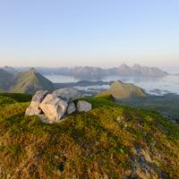
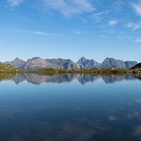
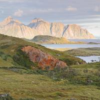
At the northwest tip of Vestvågøya Island, in a part of the archipelago that is still rarely visited, the discreet summit of Hellostinden holds pride of place. The walk to the top goes over relatively easy terrain through open landscapes. The panorama is magnificent from the summit, particularly the view of the Vågakallen massif on the neighboring island of Austvågøya. A hike for the whole family.
More information about this hike...
 You can read the detailed description of this hike (as well as 59 other hike descriptions), enjoy hundreds of photos, maps and practical information on the paper guidebook Hiking the LOFOTEN ISLANDS.
You'll find the guidebook on ![]() , as well as at the following bookstores, for 24,07£ (not including shipping).
, as well as at the following bookstores, for 24,07£ (not including shipping).
 Yes
Yes Yes
Yes Yes
Yes
https://www.rando-lofoten.net/en/hiking-to-hellostinden#sigProId5b630c6424


Download the route |
Hellostinden.gpx |
Join the start of the hike with Google Maps
You can use your actual location or enter the name of the place from which you wish to start