Hiking to Kongstindan
 Medium
 Austvågøya
 2 to 3 hrs
 4.88 km
 550 m
550 m 530 m
530 m Vågan
Vågan Until May at the summit
- Type of hike : Go back
- Visibility of the route : Good
- Start/Finish : Coming from Kabelvåg, leave Route E10 at the Osan crossroads (between huge sheds for repairing boats, and a gas station). Take a left onto the Kongsvatnveien road till you reach the edge of the lake. Then take the right-hand road, which becomes unpaved but drivable, and follow it for about 1 km (0.6 mi.) to the parking lot.
- GPS Point : Trail start: N68° 14.490' E14° 31.911'
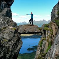
Summit: N68° 14.867' E14° 29.578' - Note : Difficult when wet. The trail goes over rocky slabs'extremely slippery when wet. That's why we advise you to choose a day of dry, clear weather for this hike. Finally, people who get dizzy should be aware that the crest line is sometimes narrow and you'll have to walk near a sheer drop in certain places.
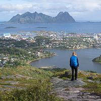
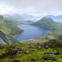
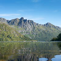
This slender peak faces the summit of Tjeldbergtinden. It is higher than Tjeldbergtinden and gives you a remarkable panorama over the town of Svolvær and the northern part of Vågan Island. You make the ascent on a good trail over a straight ridge line—sometimes dizzying, but not dangerous when the ground is dry.
More information about this hike...
|
|

 No
No No
No No
No
https://www.rando-lofoten.net/en/hiking-to-kongstindan?tmpl=component&print=1#sigProIdc2dda9f3b9


Download the route |
Kongstindan.gpx |
Join the start of the hike with Google Maps
You can use your actual location or enter the name of the place from which you wish to start


Other hikes nearby

Hiking to Varden and Stortinden
Austvågøya Medium / Difficult14.2 kmNoYesNo