")


Hiking to Sørlandshagen
 Easy / Medium
 Værøya
 45mn
45mn 1.27 km
 50 m
50 m 23 m
23 m Vest-Lofoten
 Until March
- Type of hike : Go back
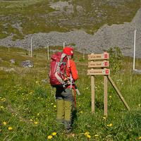
- Visibility of the route : Good
- Start/Finish : From the port of Værøy, take the 'Nordland' direction. Once you're at the hamlet, keep on Route 791 and then on the dirt track that prolongs the road to the end. Park near the toilets. The trail starts just behind the beach of Heimretussen.
- GPS Point : Starting point: N67° 40.205' E12° 39.181', parking lot
North side of the beach (Hagmolla): N67° 40.018' E12° 39.496'
South side of the beach (Hagesletta): N67° 39.743' E12° 38.973'
Cape of Nupsneset: N67° 39.058' E12° 39.138' - Extensions : Nupneset cape, medium; 2 hrs; 6,2 km; ± 150 m, max altitude 53 m
- Note : The bay gets the morning sun
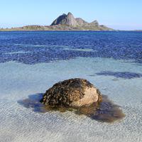
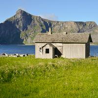
This big bay, which stretches out on a north-south axis, has a vast stony beach right under impressive granite cliffs. Between the beach and the cliffs there is extended an area of dunes, covered by a meadow with very low vegetation. Traces of human inhabitants from the stone age to the Middle Ages have been found on the southern part of the beach (Hagsletta). More recently the area around the bay was used as a sheep pasture until the 1960’s. The spot is both wild and easy to get to.
More information about this hike...
|
|

 Yes
Yes Yes
Yes No
No
https://www.rando-lofoten.net/en/hiking-to-sorlandshagen#sigProId5ab0a2c262


Download the route |
Sorlandshagen.gpx |
Join the start of the hike with Google Maps
You can use your actual location or enter the name of the place from which you wish to start

Download the route | Cap_de_Nupsneset.gpx |