Hiking to Justadtinden

DifficultyMedium
LocationVestvågøya
Duration5 to 6 hrs
Distance12.27 km
Climb900 m
Maximum altitude715 m
Map - 1:50 000Vestvågøy
Snow riskUntil June at the top
  • Type of hike : Return trip (or possible loop if going down by Steindalstinden)
  • Visibility of the route : poor if going down by Steindalstinden
  • Start/Finish : Hagskardet/Hagskardet (road 815)
  • GPS Point : Start/Finish: N68 09.481 E13 41.688
    Summit: N68 10.931 E13 48.202
    Branch to Steindalstinden: N68 10.682 E13 45.575"
Vestford view from the top of Justadtinden (Lofoten)
Description


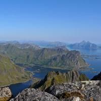
This magnificent hike runs along the ridges that overlook the plain of Leknes to the north and the majestic Vestfjord to the south. Throughout the hike you will be treated to a series of breathtaking views.


More information about this hike...

Cover EN ptYou can read the detailed description of this hike (as well as 59 other hike descriptions), enjoy hundreds of photos, maps and practical information on the paper guidebook Hiking the LOFOTEN ISLANDS.
You'll find the guidebook on logo amazon en, as well as at the following bookstores, for 24,07£ (not including shipping).

Order on Amazon

Accessibility
No
Yes
Yes
Slideshow
View the embedded image gallery online at:
https://www.rando-lofoten.net/en/justadtinden-en#sigProId8c7b82164f
 
Download the route
Justadtinden.gpx

Join the start of the hike with Google Maps

You can use your actual location or enter the name of the place from which you wish to start

Other hikes nearby

Hiking to Slettheia

Hiking to Slettheia

Located at 0.4 km
Vestvågøya
DifficultéEasy
7.6 km

Accessibility
Yes
Yes
No
Hiking to Kangerurtinden

Hiking to Kangerurtinden

Located at 4.2 km
Vestvågøya
DifficultéDifficult
4.9 km

Accessibility
No
No
No
Hiking to Bulitinden and Guratinden

Hiking to Bulitinden and Guratinden

Located at 4.4 km
Vestvågøya
DifficultéMedium
9.9 km

Accessibility
Yes
Yes
No
Einangen to Mortsund

Einangen to Mortsund

Located at 5.2 km
Vestvågøya
DifficultéMedium
4.8 km

Accessibility
No
No
No

Copyright

Any representation whether total or partial of this site or content (general structure, texts, sound, logos, images whether animated or otherwise), by any method whatsoever, without the authors express prior approval is prohibited and constitutes infringement sanctioned by the Intellectual Property Code. The GPX tracks that can be downloaded on this website, bellong to hiking-lofoten and is for a private use only (not for commercial use). In order to reproduce the tracks in any form or on any medium (paper, digital, website, etc.), we ask you to mention the following (under or on the map): GPX track © hiking-lofoten.net