Hiking to Munkan
 Medium / Difficult
 Moskenesøya
 6 to 7 hrs
 12.81 km
 1100 m
 766 m
766 m Vest-Lofoten
 Until June on the summit
- Type of hike : Go back (or loop if going down by Kjølen)
- Visibility of the route : Good
- Start/Finish : From Sørvågen village
- GPS Point : Start/finish: N67 53.583 E13 00.440Start/finish: N67 53.583 E13 00.440
Summit : N67 55.955 E13 01.167
Summit : lon: N67 55.955 E13 01.167
Description
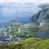
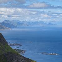
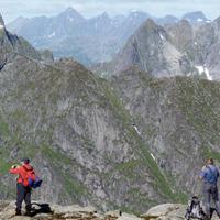
When the weather is clear you get undoubtedly the best view of the south of the islands from the top of Munkan. This route is very popular with the inhabitants of the islands and, what is rare in the Lofoten Islands, there is a real path to the top.
More information about this hike...
|

Accessibility
 No
No Yes
Yes No
No Slideshow

View the embedded image gallery online at:
https://www.rando-lofoten.net/en/munkan-en?tmpl=component&print=1#sigProId69fcfc7ec2
https://www.rando-lofoten.net/en/munkan-en?tmpl=component&print=1#sigProId69fcfc7ec2
Video


Download the route | Munkan.gpx |
Join the start of the hike with Google Maps
You can use your actual location or enter the name of the place from which you wish to start