From Myrland to Vikten
 Medium
 Flakstadøya
 4:30 hrs
 7.97 km
 560 m
560 m 499 m
499 m Vest-Lofoten
 Until June on the summit
- Type of hike : Crossing
- Visibility of the route : Poor in the begining, good in the last part
- Start/Finish : To reach Myrland, if you are coming from the south of the islands leave the E10 after crossing the village of Napp and take the small road to the right approximately 300m before the tunnel leading to the island of Vestvågøya. Myrland is at the end of the road.
- GPS Point : Start: N68 09.640 E13 22.071
Finish: N68 08.318 E13 18.701

Description
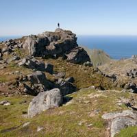
This hike begins in the isolated hamlet of Myrland (literally “peatland”) in the extreme north of the island of Flakstad and end in the village of Vikten via several valleys and a series of passes.
More information about this hike...
|

Accessibility
 No
No Yes
Yes Yes
Yes Slideshow

View the embedded image gallery online at:
https://www.rando-lofoten.net/en/myrland-vikten-en?tmpl=component&print=1#sigProId735c0032d5
https://www.rando-lofoten.net/en/myrland-vikten-en?tmpl=component&print=1#sigProId735c0032d5


Download the route | MyrlandVikten.gpx |
Join the start of the hike with Google Maps
You can use your actual location or enter the name of the place from which you wish to start