")


Hiking to Tjeldbergtinden
 Easy
Easy Austvågøya
 3 to 4 hrs
 7.62 km
 500 m
500 m 353 m
353 m Vågan
Vågan Until May on the summit
- Type of hike : Crossing or loop (by the path along Kongselva)
- Visibility of the route : Good
- Start/Finish : Osan (Svolvaer)/Kabelvag
- GPS Point : Start: N68° 13.946' E14° 31.856'
Summit: N68° 13.784' E14° 29.950'
Finish (if Kabelvåg): N68° 12.559' E14° 28.908'
Description
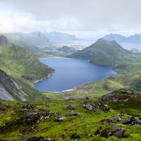
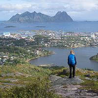
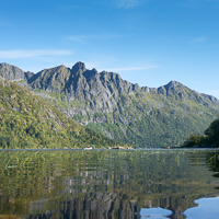
This is a short cross-country hike that takes you to the peak overlooking the town of Svolvær in half a day. Leaving Svolvær you climb to a small plateau that has a number of fine viewpoints.
More information about this hike...
|
|

Accessibility
 Yes
Yes Yes
Yes Yes
Yes
Slideshow

View the embedded image gallery online at:
https://www.rando-lofoten.net/en/tjelbergtinden-en#sigProId7e5e0c3e13
https://www.rando-lofoten.net/en/tjelbergtinden-en#sigProId7e5e0c3e13


Download the route |
Tjeldbergtinden.gpx |
Join the start of the hike with Google Maps
You can use your actual location or enter the name of the place from which you wish to start


Other hikes nearby


Hiking to Varden and Stortinden
Located at 2.9 km
Austvågøya Medium / Difficult14.2 km
Accessibility
NoYesNo