NETHERLANDS
DE NOORDERZON - Reisboekhandel
Nieuwstad 35,
6811BJ Arnhem - Nederland
Tel: +31(0)263510334 - www.denoorderzon.nl
English version only
FRANCE
ARIANE - LA LIBRAIRIE DU VOYAGE
20 rue du capitaine Dreyfus
35000 Rennes - France
Tel: +33 (0)2 99 79 68 47
www.librairie-voyage.com
French version only
LIBRAIRIE AU VIEUX CAMPEUR
2, rue de Latran
75005 Paris - France
Tel: +33 (0)1 53 10 48 33
www.auvieuxcampeur.fr/librairie
French version only
LA COMPAGNIE DES CARTES
Moose Crossing SARL
18 chemin de la briqueterie
33610 Canéjan
FRANCE
https://lacompagniedescartes.fr/
French and English version online
LIBRAIRIE LA GÉOTHÈQUE
14, rue Racine
44000 Nantes - France
Tel: +33 (0)2 40 74 50 36
https://www.facebook.com/La-Géothèque
French version only
LIBRAIRIE EYROLLES
Librairie Eyrolles
55, 57 et 61 boulevard Saint-Germain
75005 Paris - France
Tel: +33 (0)1 44 41 11 74
www.eyrolles.com
French version only
LIBRAIRIE ITINÉRANCES
62, rue Baudrière
49000 Angers - France
Tel: +33 (0)2 41 77 36 47
www.librairie-voyage-angers.fr
French version only
SWISS
LE VENT DES ROUTES S.A.
50 rue des Bains
CH-1205 Genève - Suisse
Tel: +41 22 800 33 81 - www.vdr.ch
French and English version
PAYOT LIBRAIRE
Place Pépinet 4
CH-1003 Lausanne - Suisse
Tél: +41 21 341 33 31 - www.payot.ch
English version only
PAYOT LIBRAIRE
Rue de la Confédération 7
CH – 1204 Genève - Suisse
Tél: +41 22 316 19 00 - www.payot.ch
English version only
BELGIUM
ANTICYCLONE DES AÇORES
Rue fossé aux Loups 34
1000 Bruxelles - Belgique
Tel: +32 02/217 52 46 - www.anticyclonedesacores.be
French and English version
NORWAY
RØDSAND LIBRIS LEKNES
Storgata 8,
8370 Leknes - NORWAY
Tel: +47 76 07 59 38
English version only
SKANDINAVISK HØYFJELLSUTSTYR BODØ
Torvgata 2,
8006 Bodø - NORWAY
Tel: +47 75 52 23 10 - www.skandinaviskhoyfjellsutstyr.no/Bodoe
English version only
RØDSAND LIBRIS SVOLVÆR
Vestfjordgata 8
8300 Svolvær - NORWAY
Tel: +47 76 07 59 22
English version only
BOKHUSET LIBRIS TROMSØ
Storgata 86
9008 Tromsø - NORWAY
Tel: +47 77 68 30 36
English version only
SWEDEN
NORSTEDTS FÖRLAGSGRUPP
Kartbutiken
Mäster Samuelsgatan 54
111 21 Stockholm - SWEDEN
Tel: +46 08 202 303 - https://www.kartbutiken.se/
English version only
You are a bookseller and want to be part of this list? Check our sales and shipping conditions in Europe.
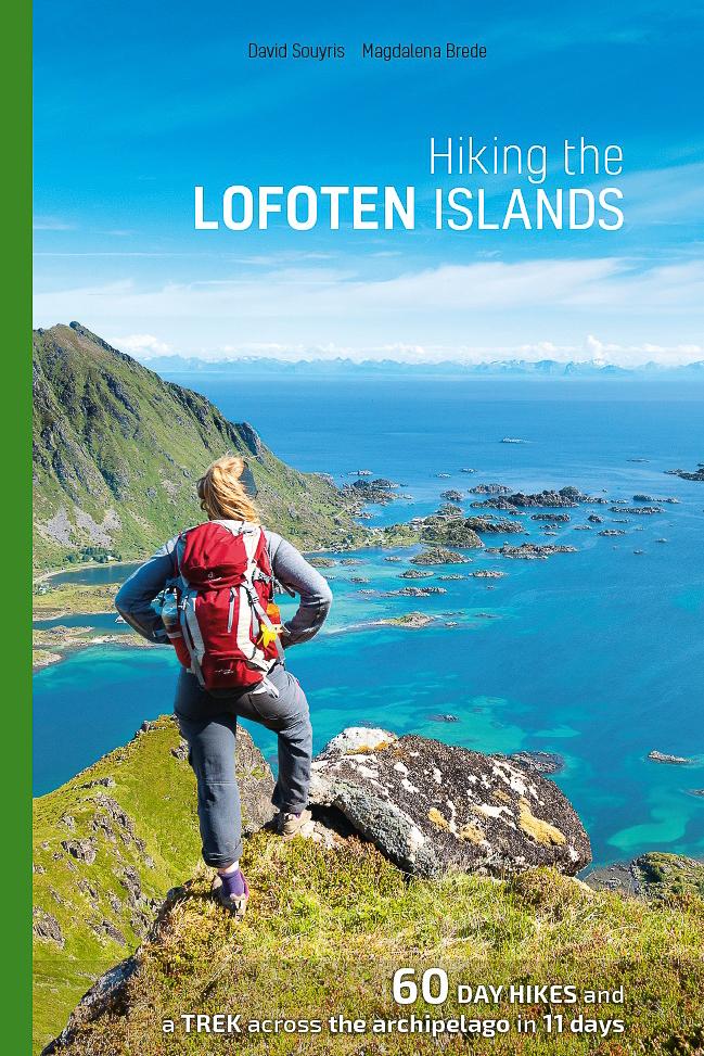
WHY THIS GUIDE?
First, our passion for this archipelago, an inexhaustible reservoir of fantastic walks. And then, our experience in guiding groups of hikers over the past ten years. Finally, above all, we realized that up to now the available cartography has been limited to a collection of acceptable maps— but not quite acceptable for hiking. The trail indications are often meager and sometimes incorrect.
We wanted to remedy this fl agrant lack of reliable information as
completely as possible..
OUTLINE OF THE TOPO-GUIDE
Hiking the Lofoten Islands is both an invitation to discover this bit of Arctic paradise and a practical guidebook that answers two questions, essential for any hiker:
• Where should I hike on each of the islands, given the time I have, theweather, and my physical condition?
• What itineraries should I follow?
This guidebook is divided into three parts
- Part One is an introduction to the islands. You’ll fi nd general information on their geography, climate, geology, animal and plant life as well as advice on how to prepare for your hikes.
- Part Two is composed of 60 hiking topo-pages that include all the information you need—descriptions, maps and photos—to discover and appreciate the trails in the best possible way.
- Part Three describes a trek across the archipelago in 11 days. In addition to a detailed itinerary, it has all the tips you’ll need on food supplies and preparation for the hike and your bivouacs.
Buy this book?
You can order the book on Amazon or at traditional bookstores (see booksellers list here)
Order the book now on Amazon.fr
(shipping possible to all over Europe and most of the World, fixed price at: 28€)
You can also order the book on:
Amazon.es, Amazon.it, Amazon.nl (for the Netherlands and Belgium only)
If you want to support this website, please choose "Topo Guide Lofoten" seller when ordering (fixed price: 28€ or 24,07£)
PRACTICAL INFORMATION
Number of pages 224
Cover flexi-binding
Format 14,3 x 22,6 cm
Weight about 400g (1 lb.)
Price 28€ tax included
Bookstores Bookstores and resellers get a discount on our sales prices excluding taxes (without VAT). Depending on the quantity that is ordered, you can get from 25% up to 40% off.
You are authorized to fix your own retail price as long as it is not under our sales price (so you can sell it at a higher price).
For detailled information about: bookseller discounts, shipping costs, please send us an email at: This email address is being protected from spambots. You need JavaScript enabled to view it. and will send you a document will all the information that you need. For all orders, please send an e-mail to: This email address is being protected from spambots. You need JavaScript enabled to view it.
…and be sure to tell us the following:
Number of copies ordered
Contact (person responsible for the order)
Name and contact information of your bookstore (address, telephone, etc.)
Address and billing address (if different from bookstore address) Method of payment: When we’ve received your order, we’ll send you an e-mail with an invoice. You can pay by bank transfer (preferred), or through PayPal (either with a PayPal account or with a credit card).
Payment has to be done no later than 30 days after invoicing, we send the order within 2 business days. |

")