")


Hiking to Himmeltindan
 Medium / Difficult
 Vestvågøya
 5 hrs
5 hrs 7.71 km
 1000 m
 923 m
923 m Vestvågøy
 Until June on the summit
- Type of hike : Go back
- Visibility of the route : Good
- Start/Finish : Haukland/Haukland
- GPS Point : Start/finish: N68 11.957 E13 31.635
Summit: N68 13.067 E13 34.312

Description
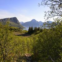
A tough but enjoyable climb to the “Top of the Sky” (Himmeltindan). You can start from the beautiful beach of Haukland with its white sand and turquoise waves before climbing the old track that used to give access to the village of Utakleiv before the tunnel was built in the 20th century.
More information about this hike...
|
|

Accessibility
 No
No No
No No
No
Slideshow

View the embedded image gallery online at:
https://www.rando-lofoten.net/en/himmeltindan-en#sigProId0c7d352fe4
https://www.rando-lofoten.net/en/himmeltindan-en#sigProId0c7d352fe4


Download the route |
Himmeltinden.gpx |
Join the start of the hike with Google Maps
You can use your actual location or enter the name of the place from which you wish to start