")


Hiking to Stornappstinden
 Medium
 Flakstadøya
 4:30 hrs
 4.67 km
 800 m
800 m 735 m
735 m Vest-Lofoten
 Until June at the summit
- Type of hike : Go back
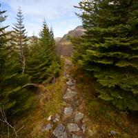
- Visibility of the route : Good
- Start/Finish : Travelling south on the E10, 2.5 km beyond the village of Napp take the right-hand track and use the car park near the reservoir.
- GPS Point : Start/finish: N68 07.830 E13 23.398
Summit: N68 08.647 E13 24.897

Description
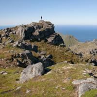
When you leave the island of Vestvågøy to go south of the Lofoten Islands, you see the summit of Stornapptinden rising up like a solitary impressive sentry facing the Straits of Nappstraumen.
More information about this hike...
|

Accessibility
 No
No Yes
Yes No
No Slideshow

View the embedded image gallery online at:
https://www.rando-lofoten.net/en/stornappstinden-en#sigProId91291cb0fb
https://www.rando-lofoten.net/en/stornappstinden-en#sigProId91291cb0fb


Download the route | Stornappstinden.gpx |
Join the start of the hike with Google Maps
You can use your actual location or enter the name of the place from which you wish to start