Hiking to Brunakseltinden
 Medium
 Moskenesøya
 3 hrs
3 hrs 8.03 km
 600 m
600 m 523 m
523 m Vest-Lofoten
 Until May at the top
- Type of hike : Go back
- Visibility of the route : Good
- Start/Finish : Leave from the main wharf (landing stage) in Vinstad
- GPS Point : Start/finish : N67 57.477 E13 00.229
Description
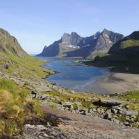
From the village of Vinstad, which can only be reached by boat, walk the length of the fjord along the village’s only street. At the end of the fjord take the trail on your left towards the Einangen pass.
More information about this hike...
|
Accessibility
 No
No No
No No
No Slideshow
View the embedded image gallery online at:
https://www.rando-lofoten.net/en/hiking-to-brunakseltinden?tmpl=component&print=1#sigProId45986afe70
https://www.rando-lofoten.net/en/hiking-to-brunakseltinden?tmpl=component&print=1#sigProId45986afe70

Download the route | Brunakseltinden.gpx |
Join the start of the hike with Google Maps
You can use your actual location or enter the name of the place from which you wish to start


