


Go back, Crossing
Bonne, Moyenne
There are several possible ways of tackling this hike, but we have chosen the one that seems to us both the most interesting and the least difficult, namely crossing from Forsjorden to Sorvågen. You do this by catching a boat at Reine to Forsfjorden kraftstasjon (the miniature hydroelectric plant at Forsfjorden). A shuttle leaves Reine every day for Vinstad and Kjerkfjord. If you are prepared to pay extra you can ask to be dropped at Forsfjorden. The path starts on the right-hand side behind the miniature hydroelectric plant (alongside the water outflow).
Quay of Forsfjorden : N67 56.328 E12 58.996
Summit : N67 56.520 E12 56.281
Description
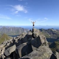
As the highest peak on the island of Moskenesøya, Hermannsdalstinden attracts certain hikers who want to be able to say they have conquered this Norwegian Everest. Aside from this rather meaningless “altitude record”, the hike itself, although certainly long, is fairly accessible and passes through absolutely magnificent alpine landscapes. The view from the top on a clear day is breathtaking!
More information about this hike...
|
|

Accessibility
Not defined


