Hiking to Ballstadheia

DifficultyMedium
LocationVestvågøya
Duration4 to 5 hrs
Distance7.5 km
Climb650 m
Maximum altitude456 m
Map - 1:50 000Vestvågøy
Snow riskUntil June at the top
  • Type of hike : Loop
  • Visibility of the route : Medium
  • Start/Finish : Kraemmervika veien (behind the Havets Helter restaurant)
  • GPS Point : Start/finish: N68 03.939 E13 32.045
    Start from Graenvika: N68 03.792 E13 29.729
    Nonstinden top: N68 04.316 E13 30.323
  • Note : Not recommended if snowy or iced
Close of the top of Ballstadheia - Lofoten
Description


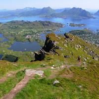
This pleasant hike around the back of the village of Ballstadlandet takes you around the Vestfjord along a narrow coastal path before reaching a cape and then climbing back along a steep path up to the plateau of Ballstadheia.


More information about this hike...

Cover EN ptYou can read the detailed description of this hike (as well as 59 other hike descriptions), enjoy hundreds of photos, maps and practical information on the paper guidebook Hiking the LOFOTEN ISLANDS.
You'll find the guidebook on logo amazon en, as well as at the following bookstores, for 24,07£ (not including shipping).

Order on Amazon

Accessibility
Yes
Yes
No
Slideshow
View the embedded image gallery online at:
https://www.rando-lofoten.net/en/ballstadheia-en#sigProId2077ecd8d7
 
Download the route
Ballstadheia.gpx

Join the start of the hike with Google Maps

You can use your actual location or enter the name of the place from which you wish to start

Other hikes nearby

Hiking to Breidtinden

Hiking to Breidtinden

Located at 0.6 km
Vestvågøya
DifficultéMedium
9.9 km

Accessibility
Yes
Yes
No
Einangen to Mortsund

Einangen to Mortsund

Located at 7.4 km
Vestvågøya
DifficultéMedium
4.8 km

Accessibility
No
No
No
Hiking to Bulitinden and Guratinden

Hiking to Bulitinden and Guratinden

Located at 7.5 km
Vestvågøya
DifficultéMedium
9.9 km

Accessibility
Yes
Yes
No
Hiking to Store Klauva

Hiking to Store Klauva

Located at 7.7 km
Flakstadøya
DifficultéDifficult
14.4 km

Accessibility
No
Yes
No

Copyright

Any representation whether total or partial of this site or content (general structure, texts, sound, logos, images whether animated or otherwise), by any method whatsoever, without the authors express prior approval is prohibited and constitutes infringement sanctioned by the Intellectual Property Code. The GPX tracks that can be downloaded on this website, bellong to hiking-lofoten and is for a private use only (not for commercial use). In order to reproduce the tracks in any form or on any medium (paper, digital, website, etc.), we ask you to mention the following (under or on the map): GPX track © hiking-lofoten.net