


Go back
Bonne
Nedreås Bus-stop (Route 997 - Ramviksveien)
Start/finish : N68 07.415 E13 38.685
Pass : N68 07.463 E13 41.566
Bulitinden summit : N68 07.517 E13 41.962
Guratinden summit : N68 07.112 E13 41.358
Description
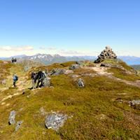
Although these two beautiful peaks above the town of Leknes (Vestvagoya) are easy to climb, they offer a spectacular panorama of the central part of the Lofoten Islands.
More information about this hike...
|
|

Accessibility
Accessible to dogs, Family friendly, Snowshoe


