From Haugen to Svolvær


- Type of hike : Crossing
- Visibility of the route : Bad
- Start/Finish : Haugen/Svolvaer
- GPS Point : Start : N68 19.539 E14 30.632
Finish : N68 14.134 E14 33.667
Summit : N68 17.159 E14 30.325 - Note : Due to the steep gradient, the path above Lake Svartvatnet is dangerous when the path is under snow.
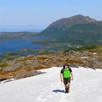
This hike takes you from one side of the island of Austvågøya to the other via a fine range of mountains.
More information about this hike...
|


https://www.rando-lofoten.net/en/haugen-en#sigProIdc604073d89

Download the route |
Haugen_Svolvaer.gpx |
Join the start of the hike with Google Maps
You can use your actual location or enter the name of the place from which you wish to start