Vikjorda to Brustranda

DifficultyMedium / Difficult
LocationVestvågøya
Duration7 hrs
Distance17.01 km
Climb1050 m
Maximum altitude534 m
Map - 1:50 000Vestvågøy
Snow riskUntil begining of June at the summit
  • Type of hike : Crossing
  • Visibility of the route : Poor to nonexistant
  • Start/Finish : From Leknes take road 815 towards Stamsund to the hamlet of Storfjorden. Turn left and continue along road 815 towards Valberg and Vikjorden. Drive as far as Vikjorden (Vikjorda) and park near the Rebecca café (on the left of the road). The path starts 5 metres to the left of the café.
  • GPS Point : Start : N68 13.635 E14 04.610
    Finish : N68 12.221 E13 52.836
    Vardheia : N68 13.813 E13 56.485
    Sara Stein : N68 13.587 E13 55.735
    Trail start in Hestbergan pass : N68 13.542 E13 53.681
    Point 232m : N68 12.854 E13 49.523
  • Note : For the first part of this hike you should refer to Dalstuva hike
Vikjorda-Brustranda-1
Description


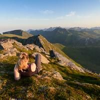
This good 17 km hike takes you from the bay of Malnesvika as far as the fjord of Rolvsfjorden. The route passes through mountain and valley landscapes where the only living things are a few sheep. The more rounded mountains, unspoilt valleys and plateaus covered with peatland make this little-known and still rarely visited part of the island of Vestvågøya worth the detour.


More information about this hike...

Cover EN ptYou can read the detailed description of this hike (as well as 59 other hike descriptions), enjoy hundreds of photos, maps and practical information on the paper guidebook Hiking the LOFOTEN ISLANDS.
You'll find the guidebook on logo amazon en, as well as at the following bookstores, for 24,07£ (not including shipping).

Order on Amazon

Accessibility
No
Yes
Yes
Download the route
Vikjord-Brustranda.gpx

Join the start of the hike with Google Maps

You can use your actual location or enter the name of the place from which you wish to start

Other hikes nearby

Hiking to Trolldalstinden

Hiking to Trolldalstinden

Located at 0.0 km
Vestvågøya
DifficultéMedium / Difficult
10.4 km

Accessibility
No
Yes
No
Hiking to Vikjordtinden

Hiking to Vikjordtinden

Located at 0.0 km
Vestvågøya
DifficultéMedium / Difficult
6.9 km

Accessibility
No
No
No
Hiking to Dalstinden

Hiking to Dalstinden

Located at 2.4 km
Vestvågøya
DifficultéMedium
6.2 km

Accessibility
Yes
Yes
No
Hiking to Varden

Hiking to Varden

Located at 2.7 km
Vestvågøya
DifficultéEasy
5.6 km

Accessibility
Yes
Yes
No

Copyright

Any representation whether total or partial of this site or content (general structure, texts, sound, logos, images whether animated or otherwise), by any method whatsoever, without the authors express prior approval is prohibited and constitutes infringement sanctioned by the Intellectual Property Code. The GPX tracks that can be downloaded on this website, bellong to hiking-lofoten and is for a private use only (not for commercial use). In order to reproduce the tracks in any form or on any medium (paper, digital, website, etc.), we ask you to mention the following (under or on the map): GPX track © hiking-lofoten.net