Hiking to Holandsmelen


- Type of hike : Crossing or back and forth
- Visibility of the route : Good
- Start/Finish : Coming from Leknes on the E10 towards Napp, take the small road on the right immediately after the bridge that crosses Offersøystraumen towards Haukland Beach. Roughly 200m after Høgtaen you will reach a car park on the right of the road, just before the pass.
- GPS Point : Start/finish: N68° 10.555' E13° 31.477'
Summit: N68° 11.379' E13° 35.231'
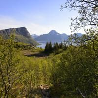
This large hill surrounded by water on either side is easily climbed due to its rounded shape and the good trail that crosses it. Even though the peak is not particularly high, it boasts an outstanding 360° view with the Leknes plateau and Buksnesfjord to the east and south, the Norwegian Sea to the west and, to the north, the impressive Himmeltindan mountain that towers almost 1000m above sea level. An easy hike that is great to do as a family.
More information about this hike...
|


https://www.rando-lofoten.net/en/holandsmelen-en#sigProIdf2a71c8f08

Download the route | Holandsmelen.gpx |
Join the start of the hike with Google Maps
You can use your actual location or enter the name of the place from which you wish to start