


Loop
Bonne, Moyenne
If you are coming from the north (Ramberg) via the E10, you will see a place where you can park to the right of the road 600m after Finnbyen (a large hangar surrounded by strong-smelling fish driers). Park and cross the road to where the trail begins in a little valley.
Start/Finish: N68 03.865 E13 11.691
Summit of Volandstinden : N68 04.246 E13 12.652
Summit of Nesfjellet : N68 03.490 E13 12.185
Description
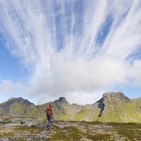
The top of Volandstinden is one of those peaks which, when seen from the road, seems totally inaccessible to hikers. It is, however, easy to climb without any particular difficulty. The steep peak also means it has a unique view over the island of Flakstadoya and bay of Ramberg.
More information about this hike...
|
|

Accessibility
Accessible to dogs


