Kayaking in the Lofoten Islands

WHAT COULD POSSIBLY BE NICER THAN DISCOVERING THE ARCHIPELAGO ALONG THE COASTLINE, AND WITHOUT THE NOISE OF AN ENGINE?

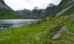
Hiking is not the only possible outdoor activity  in the Lofoten. In recent years sea kayaking has attracted a growing number of tourists and locals. The archipelago and its east coast is a paradise for all experienced kayakers and more broadly for all lovers of marine life, marine landscapes ... and tranquility.

group of tourists on a kayak trip with exploranor

> OUR ADVICE

Unfortunately the Norwegian outdoor agencies practice quite prohibitive prices and a guided day-trip within a group (5-7h) by one of these agencies can easily reach 2000NOK / person (or 950NOK / half-day). And this is without meals or services other than the equipment and guiding. For a one-time experience it is pretty expensive for most of us, and if you entend to do several kayak excursion during your stay in the Lofoten, you will probably have to break the bank.

A more economical solution, and provided you have a good experience in sea kayaking, is to rent one on site *. The ideal, if you have the opportunity, being of course to bring your own kayak on the top of your car!

Be careful though to the different marine currents (including the Maelstrom) and the tidal effects that combined can be very dangerous, not to mention bad weather. Always learn about the upcoming marine weather (check it hour by hour) and do not venture on the west coast of the archipelago unless you have very favorable weather conditions and a great experience in autonomous sea kayaking. Finally, do not leave alone and always seek advice from locals who are usually very familiar with the currents and dangers at sea near their homes.

If you are not an expert in sea kayaking and group life does not deter you, we strongly advise you to opt for a guided tour.
Through our partner's travel agency EXPLORANOR, we can offer one week long all-inclusive trip in Lofoten at a very reasonable price.

group of tourists on a kayak trip with exploranor

To learn more about the trip, have a look at their trip here.

You can also consult the travelers' feedback on the page of the tour, or on tripadvisor

* NB: The Norwegians are rather strict regarding safety rules, so if you want to venture alone on the fjord and rent a kayak on site, you will always be asked for a certificate proving that you have already had a first experience in sea kayaking.

Search the site ...

Advertisment

Planning your hiking trip to the Lofoten Islands?
Don't wait to be on site, and get them online at the "Maps Company", our official partner.

MapsCompany 400px 210x Maps Company is selling travel and hiking maps for all over the planet. The products are shiped within 24 hours, all over the world. They offer over 17,000 travel and hiking maps (over 200 countries).

To order hiking maps for the Lofotens, click here

Connection

In order to access certain services available on our site, (participation in forums, access to hiking sheets) you must register.

Boat Shuttle

Reine/Vindstad/Kjerkfjord

forsfjord vindstad

If you want to go from Forsfjord power station to Vindstad (or vice versa), and you don’t want to rely on the boat shuttle MS Fjordkyss, it is now possible to do it by foot.

We provide GPX track, map and the description (in french only) for the section connecting Vindstad to Forsfjord. This new possibility is particularly interesting for hikers engaged in the great crossing of the Lofoten Islands trek.

Our tips

Where to sleep, eat, drink and more in the Lofoten Islands

As we are not a tourist office, we will only publish recommandations for places we think are hikers and backpackers friendly and that we have tested AND appreciated. This section will get more stuff as we go along.

Who is online ?

We have 1060 guests and no members online

Lofoten Webcams

Updated every 40min

North of the archipellago

Laukvik
Brotoy: E Raftsundet
Kabelvag: Ip kamera skistua, kongstind
Henningsvær - Austvågøya

Center of the archipellago

Steine: F Hagskaret (Retning Stamsund)
Ballstad: havn i Lofoten, Vestvågøy, Nordland

South of the archipellago

E10 Kåkernbrua - Moskenesøya
Vindstad: E Akkarvika

Latest news

 Visitor statistics

161,424 users, 24,000 subscribers and over 1,500,000 pages viewed in 2018!

To find out more about all the Rando-Lofoten visitor statistics with accurate data from Google Analytics, click here

 Increasingly accurate maps!

The Day Walks section has been improved thanks to the work of Frank Ingermann and the fantastic vector map background of Norgeskart.no (Norwegian Mapping Authority - Karverket). Hiking-Lofoten offers hiking guides that are getting ever more accurate and professional. Come and find out about them!

norgeskart-


Download the official Lofoten Islands maps

Lofoten Islands maps, scale 1:50 000 (UMT33)  download them for free on hiking-lofoten!Maps from the Norwegian National Institute of Cartography (Kartverket) are available in high definition (Tiff) on a set of ten maps.  Essential to prepare your hikes in the Lofoten Islands...

Lofoten maps

Northern lights forecast

Discover aurora forecast for Lofoten islands, thanks to NOAA POES satelitte from the "National Oceanic and Atmospheric Administration"

GPS routes

  • The GPS hiking routes are finally available as free downloads from the Hikes section!
  • Discover eight new routes in the Lofoten Islands with detailed Topos from Rando-Lofoten.

Day Length in the Lofoten

The Lofoten archipelago is located above the Arctic Circle, the result of this situation is a period of permanent days in summer and at the opposite a period of permanent night in winter (polar night).

To organize properly your trips and expedition in this region, it is important to take this phenomenon into account due to the high latitude. Discover our sunset/sunrise calendar

Copyright

Any representation whether total or partial of this site or content (general structure, texts, sound, logos, images whether animated or otherwise), by any method whatsoever, without the authors express prior approval is prohibited and constitutes infringement sanctioned by the Intellectual Property Code. The GPX tracks that can be downloaded on this website, bellong to hiking-lofoten and is for a private use only (not for commercial use). In order to reproduce the tracks in any form or on any medium (paper, digital, website, etc.), we ask you to mention the following (under or on the map): GPX track © hiking-lofoten.net