The Lofoten Islands , like a large stretch of the west coast of Norway, enjoy an exceptional climate. At this latitude, without the warm currents of the Gulf Stream the islands would be covered with ice and no vegetation could grow. In fact the warm marine currents from the North Sea give the archipelago a mild oceanic climate with average temperatures in January of 1°C in Røst to the south of the islands (in other words higher than those in mainland France at the same time of year) and cool summers with an average of 13°C in July.
Even though the temperature may occasionally rise to 30°C in July, it is common to have fine days with temperatures of 25°C during the three summer months.
But, attractive as the climate may seem, remember you are in an arctic region near the North Pole and temperatures can drop suddenly, which is why you need appropriate protective clothing (see Equipment).
I would now like to set the record straight regarding certain misconceptions about rain. Having spent every summer in the Lofoten Islands in the last ten years, as well as the ten previous years in the south-west of Norway, I can assert that, contrary to certain rumours, it does not rain constantly in the Lofoten Islands!
Read more: Climate
All you need to know before leaving…
What hike would suit my dog?
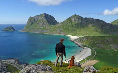 The nature of the terrain itself is difficult in the Lofotens (large screes, boulders, high steps to climb), and makes some of the hikes presented on this website simply not suitable for dogs, despite their training or abilities.
Once you're well advanced on a hike, it’s a bit late to discover that the terrain is too tough for your dog. It is also difficult to know if a dog is really tired or if it is in pain. Courageous and faithful by nature, a dog might push itself to follow you with a "smile", just to make you happy. In order to find out if the slopes are not too steep, or if the distances are not too long for your companion, it is very important to take some time to look at the maps before leaving for a hike.
In order to help you choose the right hikes, we have set up a small symbol* on the day-walk sheets. When you see this symbol, it means that you can bring a sporty and healthy dog along. Note that doing the whole trek "The Great Crossing of the Lofoten Islands" is not suitable for dogs.
* soon online
A lightweight dog (small to medium) will do better in difficult terrain
If your dog is athletic and used to rough terrain, the Lofotens can be a nice playground for it. Some hikes however, will be more like a challenging climbing route, as your dog doesn't have your leg length or a pair of arms to lift itself up in the tricky spots. A small-sized dog (or a medium dog, like a border collie for instance) will be rather an advantage here. They are generally more agile, and as you will probably need to give a helping hand from time to time (carrying your dog), it will be easier for you if it is not too heavy.
Exclude long hikes with a fragile dog or puppy
As always, watch out for dogs with weak joints (e.g. hip problems). Do not embark on a too long or too technically demanding hike (with many screes to cross...). Also, if you have a young puppy, it is not advisable to bring him hiking in a mountainous terrain because it could have adverse repercussions on his growth. If you want to bring your puppy anyway, you'll need a backpack to carry him.
Diseases or other dangers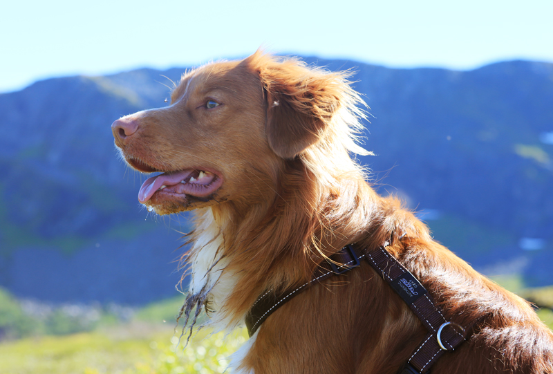
There is no particular disease to be worried about in the Lofotens.
There is no rabies in Norway and almost no ticks, except in the vicinity of sheep pastures, and generally they do not carry any diseases. So just inspect your dog after each hike where you've come across cattle (do not forget a tick twister/removal tool!). The granitic rocks are very abrasive in the long term for the digital pads of the paw (they must be inspected regularly). The water is very acidic in peat bogs and humid soils, and can therefore cause irritation between the dog's pads in the long run. Check this too, especially if your dog starts to bite the underside of its paws ... sometimes until they are bleeding!
> You will find tick removal tools in any local pharmacy (“flåttfjerner” in Norwegian).
Bathing and drinking water
Your companion will be extremely happy in the Lofotens if he loves water and is not chilly, as the sea is ubiquitous. On a hot summer day he will certainly jump into a refreshing lake to cool down. On most hikes, your dog will find lots of freshwater points that are clean enough to drink (streams, lakes), so it is not necessary to load your backpack with tons of water (check on the map if there are accessible water points on the route before leaving for a hike).
> Local supermarkets sell 33 cl bottles with a built-in drinking-trough for dogs; it's very convenient and doesn’t take much space in a backpack. You can refill the bottle during the walk.
Local laws and restrictions
Dogs must be on leash from April 1st to August 20th inclusive. This is indicated by the Norwegian law (“Lov om hundehold”), which is meant to protect farm animals and wildlife. Whatever the time of year, it is essential that your dog stay on a leash wherever there are livestock (sheep, cows...) and in areas where birds nest on the ground, especially during egg-laying (spring). If you forget this, don't worry; Norwegians will not hesitate to call you to order. However, far from homes and livestock, it is not uncommon to meet locals strolling with their unleashed dog. If your dog does not have a strong hunting instinct, it is common sense that matters. When you decide to let your dog walk free (I repeat, away from houses and sheep!), he must remain under your absolute control and come back to you at first call. This is to be taken very seriously, as there are cases in Norway every year of dogs shot by the authorities, or by the farmers themselves, following an "attack" or suspicion of attack on sheep (or similar behavior from dogs). Some local farmers will not hesitate to threaten you physically if your dog is not on a leash when you cross a pasture area (this really happened!). Another obligation: you must - of course - pick up dog leavings, and even if it is in the middle of the wilderness (yes, that’s true). There again, locals will not fail to remind you if you "forget" to do so.
How to cross the Norwegian border with a dog
Before crossing the border (a few weeks before your trip), check that all documents are in order (European pet passport, chip, vaccines, compulsory deworming treatment against echinococcosis, etc.). Whether you arrive by plane or car, you have the obligation to declare your pet to customs when entering the country. They will check the passport and check if your dog's got the compulsory deworming treatment before entering the Norwegian territory (and that this has been done within the legal deadlines).
> To learn more about pet entry requirements, please visit the following page: mattilsynet.no
Taking the ferry with your dog?
For ferry crossings between Bodø and Moskenes (3 hrs 20 min), your dog will have to wait in the car (note that the car deck is not accessible during the crossing). If you are travelling on foot, your four-legged friend will have to stay in a special compartment at the bottom of the boat - near the engines - where it is very noisy (this means in fact: very SCARY for most dogs). There you will find some stainless-steel cages and water. You'll be able to visit your dog during the crossing at least once, on request, or you can stay at its side. Bring a blanket for the cage!
Accommodations:
Most accommodation accepts dogs, but you should check this beforehand and you'll usually have to pay an extra cleaning fee.
Vets in Lofotens
In case of minor or major concern, know that there is a veterinary center in Leknes (https://www.facebook.com/lovetsenter.no/ +47 76 08 29 99) and another in Svolvær (http: //www.lofotendyreklinikk.no/ +47 76 07 16 17).
Travelers’ feedback
Health rules in public areas (cafes, restaurants, shops, etc.) are as strict as they can get towards dogs (except for guide dogs and police dogs) and the fear of allergies - however rare they may be - is close to hysteria in my view.
Unlike many European countries, you will not be able to bring your dog with you while shopping (it's forbidden, and not only in food stores!). You will not be able to drink a coffee inside either. Your four-legged friend will be confined to stay in the car or tied to a pole in the street when you've got things to do in town.
Note that it is also complicated to take the bus with a dog, even if some drivers kindly accept it (on request of course, and if there are no passengers opposed to it).
Although there is a growing craze for dogs in the bigger Norwegian cities (one can even speak of a real trend), they are relatively rare in the Lofoten Islands. Because there are not many of them, and even if they are generally obedient, they are rarely socialized and will often be afraid of your own companion, to which they will respond with surprising aggressiveness. Moreover, fearing drama in the case of a "dog encounter", the locals will keep their fuming and barking hounds on a short leash and may easily make a detour of 50 m or more just to avoid you.
Finally and without wanting to generalize, negative reactions towards you and your dog might surprise you (suspicious looks, sometimes even disgusted looks), especially if you come from the Netherlands, the US, Germany, Belgium or the United Kingdom - where dogs are respected, and have their place next to humans, whether it is in town or elsewhere. This will hopefully change in the future, but slowly, because animal welfare is not a great concern yet and the Norwegian law does still not recognize the sentient nature of animals.

Text and photos by Magdalena (H.-L.)
BY BUS:
Buses are high quality but not very frequent (on average 2 each day in both directions) and relatively expensive*. Including stops and changes of bus it takes half a day to travel the 150 km between Svolvaer and A i Lofoten** .
To find out the times.
*Example: 158Nok/person from Moskenes to Svolvaer, count 3hrs to 3:30hrs travel time (depending on connections in Leknes).
**to find out how to read the time tables, please refer to the timetables in : "How to get to the Lofoten Islands"
BY CAR:
Undoubtedly the most practical if you want to be independent. If you don’t have your own car you can hire one when you get there. In the high season (July and early August) it is, however, sometimes difficult to find rental vehicles available. The local Exploranor agency can provide hire cars and book your accommodation using the liberty forms.
THE "BOAT-TAXI" FROM REINE TO VINSTAD/KJERKFJORD:
To reach the end of the Reine fjord in order to explore the beach in Bunnes or hike to the Horseidet beach or Selfjorden you need to take this small boat from the centre of Reine. There are lots of people in summer, however, and you must get to the landing dock at least 30-45 minutes ahead of time. The boat leaves as soon as it is full (it doesn’t always wait until the scheduled time and may depend on the mood of the captain, which varies depending on the cycle of the moon :-)). Prices available here.
Winter (901) 01.09.14 until 15.06.15 (week 36 to 24 next year)
Departure from Reine
| Mon. | Wed. | Thu. | Fri. | Fri. | Every day *) |
From Reine | 07.00 | 11.00 | 10.00 | 08.00 | 21.30 | 15.00 |
Rostad | - | - | - | - | - | - |
From Kjerkfjorden | 07.15 | 11.15 | 10.15 | 08.15 | - | 15.15 |
From Vindstad | 07.25 | 11.25 | 10.25 | 08.25 | - | 15.25 |
Towards Reine | 08.00 | 12.00 | 11.00 | 09.00 | 22.30 | 16.00 |
*) Sunday, departure every other week (weeks of an even number: 34-36 etc.)
Times (901) from 16.06.14 to 22.06.14 and from 18.08.14 to 31.08.14 (week 25, 34 and 35)
Departure from Reine
| | Mon. | Wed./Sat. and Sun.
| Tue.-Thu. | Fri. | Fri. | Every day *) |
| From Reine | 07.00 | 11.00 | 10.00 | 08.00 | 21.30 | 15.00 |
| Rostad | - | - | - | - | - | - |
| From Kjerkfjorden | 07.15 | 11.15 | 10.15 | 08.15 | - | 15.15 |
| From Vindstad | 07.25 | 11.25 | 10.25 | 08.25 | - | 15.25 |
Towards Reine
| 08.00 | 12.00 | 11.00 | 09.00 | 22.30 | 16.00 |
*) Sunday, departure every other week (weeks of an even number: 34-36 etc.)
Times (901) from 23.06.14 to 17.08.14 (from week 26 to 33)
From Reine
| | Mon. and Fri.
| From Mon. to Fri.
| Sat. and Sun.
| Fri. | Every day
|
| From Reine | 08.00 | 10.00 | 11.00 | 21.30 | 15.00 |
| From Vindstad | 08.15 | 10.15 | 11.15 | - | 15.30 |
| From Kjerkfjorden | 08.25 | 10.20 | 11.20 | - | 15.20 |
| Rostad | - | - | - | - | - |
Towards Reine
| 09.00 | 11.00 | 12.00 | 22.30 | 16.00 |
Here is an overview of how to get to and from the Lofoten Islands. This paragraph contains direct links to the official sites of transport companies. To help you read the timetables, please refer to the box below (How to read timetables in Norway).
THE SIMPLEST WAY
By plane
1) Flight Paris (or other city)-Oslo: with SAS or Norwegian (low-cost Norwegian airline)
2) Flight Oslo-Bodø: with SAS or Norwegian (low-cost Norwegian airline).
N.B. If you choose Norwegian, make sure you will not have to spend the night in Oslo (airport) because there might be no connections between Paris (or an other city)-Oslo and Oslo-Bodø flights in the same day with this company (you will have to allow for a night in a hotel as well). Check carefully before booking.
Read more: How to get to the Lofoten Islands ?
Always remember this Norwegian proverb “There’s no such thing as bad weather, only bad clothes”. Unlike the inhabitants of the islands you will only be here for a short time. You won’t have time to wait for ideal rainfall, wind and temperature conditions before you leave your tent or Rorbu, so make sure you are properly equipped when you leave.
Equipment for all seasons:
Vital equipment
Fleece jacket
Wind/waterproof jacket (rain capes are impractical due to the terrain)
Warm underwear – Long-sleeved T-shirt + long-johns (ideally merino wool)
Hiking socks (warm)
Woollen hat
Gloves
Sunglasses
Hiking trousers
Woollen jumper
Quick-dry underwear (not cotton while hiking)
Walking shoes (waterproof if possible)
The rest
Handheld GPS
Umbrella
Water bottle or thermos flask
Knife
Walking poles (even if you are not used to using them, the terrain here is perfect for Nordic walking)
Sunscreen
Bathing suit (you never know)
Quick-drying towel
Small first-aid kit (everything is available here but more expensive than in France)
Mobile phone
Plus everything you usually take with you…
| Mosquitos: unlike the north of the Norwegian mainland, there are few mosquitos or stinging insects in the Lofoten Islands. Although, the last years we have notice some midges and other mosquitos in the evening in july and august. |
Winter equipment
Vital equipment
In addition to the all season equipment you should take:
A pair of snow shoes (if you want to leave the road)
A warm quilted jacket
A pair of under-gloves + a pair of warm gloves
A cagoule
Woollen underwear, socks and hat.
A head lamp
A pair of warm walking shoes suitable for your snow shoe fastenings.
The rest
Handheld GPS
Thermos flask
Knife
Walking poles
Sunscreen
Bathing suit (for the sauna, or the bravest of you!)
Quick-dry towel
Small first-aid kit (everything is available here but more expensive than in France)
Mobile phone
Plus everything you usually take with you…
| NB : Make the most of your rucksack to ensure you don’t overfill it. Remember you will find everything when you get there (in case you’ve forgotten anything) but that it’s more expensive than in France. Lastly, do not underestimate the cold that may come in any season at this latitude. My personal experience is that wool (particularly merino) is the best material ever invented in terms of warmth and comfort. |
Because restaurants in Norway are expensive you will probably want to prepare your own meals. That’s no problem in the Lofoten Islands as whatever your accommodation you will find food stores in most villages.
Here are a few ideas:
• food stores
• shops selling hiking equipment
• a few useful addresses
• places where you can have a drink or something to eat without ruining yourself

N.B. the opening times are given as an indication only (they are correct as of 2014).
See the short English/Norwegian food glossary
Laukvik
Food stores:
This tiny village has a “Coop Marked” food store.
Opening hours: Monday to Friday 10am to 6pm, Saturday 10am to 3pm.
Svolvaer
Food stores:
Given that this is the capital of the Lofoten Islands there are many supermarkets. The “Kiwi” shop is just before you enter the town from the south, next to one of the town’s petrol stations on the E10 road. The other supermarkets are in the town centre, including the very large “Coop Mega” in the Amphi shopping mall. The Vinmonopol State shop, which is the only store authorised to sell spirits over 5° (food stores only sell low-alcohol beer) is in the same mall. There is also a pharmacy. The prices of the same product vary enormously from one supermarket to another so if you are not in a hurry and find that certain products are really too expensive, check out the other shops because all three main supermarkets are located in the same square (Coop Mega, Rimi and Rema 1000). On the whole Rema 1000 is the cheapest in the town.
Opening hours:
Kiwi: Monday to Saturday 7am to 11pm and Sunday 10am to 9pm.
Coop mega: Monday to Friday 9am to 9pm and Saturday 9am to 8pm.
Vinmonopol: Monday to Wednesday 10am to 4:30pm, Thursday/Friday 10am to 6pm, and Saturday 10am to 3pm.
Rema 1000: Monday to Saturday 7am to 11pm.
Sports shop
Skandinavisk, the shop with the best range of hiking, climbing and kayak equipment in the town (unfortunately everything is on the expensive side).
Opening hours: Monday to Thursday 9am to 5pm, Friday 9am to 7pm, Saturday 10am to 3pm.
Cafés & Restaurants :
Bacalao, if you fancy a drink or a bite to eat we recommend this café (both friendly and classy) on the port. They serve very good coffee and excellent hot chocolate with whipped cream (the best in the archipelago). You will also find hot dishes and snacks (soup, bacalao (dried salt cod), burgers, potatoes stuffed with shrimps, etc.).
Read more: Where to go shopping?
WHAT COULD POSSIBLY BE NICER THAN DISCOVERING THE ARCHIPELAGO ALONG THE COASTLINE, AND WITHOUT THE NOISE OF AN ENGINE?
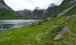
Hiking is not the only possible outdoor activity in the Lofoten. In recent years sea kayaking has attracted a growing number of tourists and locals. The archipelago and its east coast is a paradise for all experienced kayakers and more broadly for all lovers of marine life, marine landscapes ... and tranquility.

> OUR ADVICE
Unfortunately the Norwegian outdoor agencies practice quite prohibitive prices and a guided day-trip within a group (5-7h) by one of these agencies can easily reach 2000NOK / person (or 950NOK / half-day). And this is without meals or services other than the equipment and guiding. For a one-time experience it is pretty expensive for most of us, and if you entend to do several kayak excursion during your stay in the Lofoten, you will probably have to break the bank.
A more economical solution, and provided you have a good experience in sea kayaking, is to rent one on site *. The ideal, if you have the opportunity, being of course to bring your own kayak on the top of your car!
Be careful though to the different marine currents (including the Maelstrom) and the tidal effects that combined can be very dangerous, not to mention bad weather. Always learn about the upcoming marine weather (check it hour by hour) and do not venture on the west coast of the archipelago unless you have very favorable weather conditions and a great experience in autonomous sea kayaking. Finally, do not leave alone and always seek advice from locals who are usually very familiar with the currents and dangers at sea near their homes.
If you are not an expert in sea kayaking and group life does not deter you, we strongly advise you to opt for a guided tour.
Through our partner's travel agency EXPLORANOR, we can offer one week long all-inclusive trip in Lofoten at a very reasonable price.

To learn more about the trip, have a look at their trip here.
You can also consult the travelers' feedback on the page of the tour, or on tripadvisor
* NB: The Norwegians are rather strict regarding safety rules, so if you want to venture alone on the fjord and rent a kayak on site, you will always be asked for a certificate proving that you have already had a first experience in sea kayaking.
All Lofoten Islands maps in scale 1:50 000 (UMT33)
Hiking-Lofoten provides Lofoten maps. All maps can be downloaded for free in high resolution TIFF format.
Click on an area to enlarge the map
TO DOWNLOAD MAPS YOU MUST REGISTER. IF YOU ARE ALREADY A MEMBER, PLEASE SIGN IN.

All the maps offered in this section are provided by ”Kartverket” (the Norwegian National Institute of Cartography) and are licensed under creative commons by 4.0 no. Map overview above was modified by Hiking-Lofoten for its own purpose.
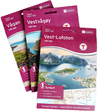 Hiking maps (paper)
Three maps on a scale of 1:50,000 cover the whole of the Lofoten islands. You can buy them once you arrive in the islands at bookshops, most food-shops, petrol stations and tourist offices. It is cheaper to buy them in the Lofoten islands than on line. They are not very detailed and the marking of the routes is sometimes rather inaccurate. They are, however, the best available unless you decide to go for a handheld GPS with a vectorial map database.
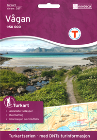
Vestvågøy
Turkart 1 :50 000
(Varenr:2673) Nordeca Buy the Map | 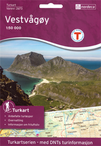 | 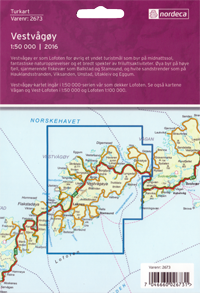 |
Vest-Lofoten
Turkart 1 :50 000
(Varenr:2745) Nordeca Buy the Map | 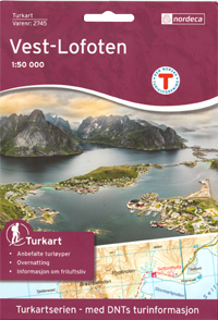 | 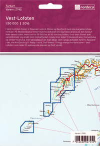 |
Ready to pay?
Vectorial maps for handheld GPS (Garmin®) - Paid Download
Norway is entirely covered by 1:50,000 vectorial maps that can be used on certain handheld GPS systems as well as on mapping software packages such as Garmin Base Camp® or Garmin Map Source®. The extremely accurate Topo Experience Pro® series, which is published for Garmin® handheld GPS systems is available on line.
The series is available as 10 DVDs:
Topo Experience PRO 01 Sørvest
Topo Experience PRO 02 Sørøst
Topo Experience PRO 03 Vest
Topo Experience PRO 04 Sentral Øst
Topo Experience PRO 05 Nordvest
Topo Experience PRO 06 Trøndelag
Topo Experience PRO 07 Nordland Sør
Topo Experience PRO 08 Nordland Nord (LOFOTEN)
Topo Experience PRO 09 Troms
Topo Experience PRO 10 Finnmark
Choose for a free solution...
Frikart.no – free access vector maps for your Gamin GPS, PC or MAC - Free
Frikart.no offers free downloadable maps! Their accuracy and quality is in our opinion as good as the other paying maps available on the market. Even better, frikart.no’s maps are on a single file that covers the entire Norway (instead of the 10 different maps that you’ll need to cover the country when using the maps powered by Garmin® for example).
The following maps can be downloaded for free (for GPS, MAC and PC):
- Roadmap (road map)
- Topo Summer (hiking map) - Download here: GPS file, Mac installer, PC installer, Installation manual (in English)
- Topo Winter (hiking map including ski trails)
- Roadmap II (road map, designated by the Norwegian Mapping Authority - only in Norwegian)
- Topo Summer II (hiking map designed by the Norwegian Mapping Authority - only in Norwegian)
- Topo Winter II (winter hiking map designed by the Norwegian Mapping Authority - only in Norwegian)
- Trails - overlay map (this map contains only hiking trails and bike trails, it is used in superposition with buyable maps such as the "TopoPro Garmin" series.
- Cross country - overlap map (same principle as for the previous map, but for ski tracks)
Help instructions to instal and use these maps on your PC, Mac or GPS devise, can be found on frikart.no (instructions are in English and Norwegian).
Lofoten map - section 10
This is an overview of the 1/50 000 scaled Lofoten Island map - 10/10
Download the Lofoten Islands map - Section 10/10 (8336 x 9093 - 750Ko)

Download the Lofoten Islands map - Section (8336 x 9093 - 750Ko)
©Kartverket - Map provided by ”Kartverket” (Norwegian National Institute of Cartography) licensed under creative commons by 4.0 no.
Lofoten map - section 9
This is an overview of the 1/50 000 scaled Lofoten Islands map - 9/10
Download the Lofoten Islands map - Section 9/10 (7159 x 9099 - 626Ko)

Download the Lofoten Islands map - Section 9/10 (7159 x 9099 - 626Ko)
©Kartverket - Map provided by ”Kartverket” (Norwegian National Institute of Cartography) licensed under creative commons by 4.0 no.
Lofoten map - section 8
This is an overview of the 1/50 000 scaled Lofoten Islands map - 8/10
Download the Lofoten Islands map - Section 8/10 (6904 x 8992 - 2.1Mo)

Download the Lofoten Islands map - Section 8/10 (6904 x 8992 - 2.1Mo)
©Kartverket - Map provided by ”Kartverket” (Norwegian National Institute of Cartography) licensed under creative commons by 4.0 no.
Lofoten map - section 7
This is an overview of the 1/50 000 scaled Lofoten Islands map - 7/10
Download the Lofoten Islands map - Section 7/10 (7900 x 8815 - 1.2Mo)

Download the Lofoten Islands map - Section 7/10 (7900 x 8815 - 1.2Mo)
©Kartverket - Map provided by ”Kartverket” (Norwegian National Institute of Cartography) licensed under creative commons by 4.0 no.
Lofoten map - section 6
This is an overview of the 1/50 000 scaled Lofoten Islands map - 6/10
Download the Lofoten Islands map - Section 6/10 (7982 x 8891 - 2.2Mo)

Download the Lofoten Islands map - Section 6/10 (7982 x 8891 - 2.2Mo)
©Kartverket - Map provided by ”Kartverket” (Norwegian National Institute of Cartography) licensed under creative commons by 4.0 no.
Lofoten map - section 5
This is an overview of the 1/50 000 scaled Lofoten Islands map - 5/10
Download the Lofoten Islands map - Section 5/10 (8066 x 8966 - 4.3Mo)

Download the Lofoten Islands map - Section 5/10 (8066 x 8966 - 4.3Mo)
©Kartverket - Map provided by ”Kartverket” (Norwegian National Institute of Cartography) licensed under creative commons by 4.0 no.
Lofoten map - section 4
This is an overview of the 1/50 000 scaled Lofoten Islands map - 4/10
Download the Lofoten Islands map - Section 4/10 (8150 x 9040 - 1.4Mo)

Download the Lofoten Islands map - Section 4/10 (8150 x 9040 - 1.4Mo)
©Kartverket - Map provided by ”Kartverket” (Norwegian National Institute of Cartography) licensed under creative commons by 4.0 no.
Lofoten map - section 3
This is an overview of the 1/50 000 scaled Lofoten Islands map - 3/10
Download the Lofoten Islands map - Section 3/10 (7815 x 8815 - 5.2Mo)

Download the Lofoten Islands map - Section 3/10 (7815 x 8815 - 5.2Mo)
©Kartverket - Map provided by ”Kartverket” (Norwegian National Institute of Cartography) licensed under creative commons by 4.0 no.
Lofoten map - section 2
This is an overview of the 1/50 000 scaled Lofoten Island map - 2/10
Download the Lofoten Islands map - Section 2/10 (7897 x 8890 - 2.4Mo)

Download the Lofoten Islands map - Section 2/10 (7897 x 8890 - 2.4Mo)
©Kartverket - Map provided by ”Kartverket” (Norwegian National Institute of Cartography) licensed under creative commons by 4.0 no.
Lofoten map - section 1
This is an overview of the 1/50 000 scaled Lofoten Island map - 1/10
Download the Lofoten Islands map - Section 1/10 (7981 x 8964 - 1Mo))

Download the Lofoten Islands map - Section 1/10 (7981 x 8964 - 1Mo)
©Kartverket - Map provided by ”Kartverket” (Norwegian National Institute of Cartography) licensed under creative commons by 4.0 no.
In this brand new section you will find our recommandations on where to sleep in the Lofoten islands... As we are not a tourist office, we will only publish recommandations for places we have tested AND appreciated. This section will get more stuff as we go along.

")