From Nesland to Nusfjord

DifficultyEasy
LocationFlakstadøya
Duration4 hrs
Distance4.9 km
Climb500 m
Maximum altitude90 m
Map - 1:50 000Vest-Lofoten
Snow riskUntil april
  • Type of hike : Go back or crossing
  • Visibility of the route : Good
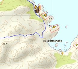
  • Start/Finish : We advise starting from Nesland (NB the road is closed in winter). Heading south towards Reine on the E10, approximately 2 km after Ramberg take the 803 on the left after the bend to Skjelfjord. After the village of Kjelfjord the road becomes a beaten-earth track. Continue to the end of the track as far as Nesland.
  • GPS Point : Start/finish (Nesland/Nusfjord) :
    Nesland: N68° 00.433' E13° 17.926'
    Nusfjord: N68° 02.036' E13° 20.891'
  • Note : Avoid this hike if the ground is icy or still covered of snow.
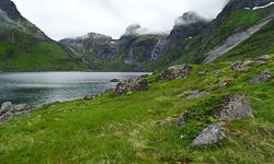
Close to Nusfjord - Lofoten
Description


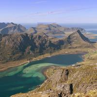
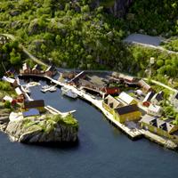
This hike is usually undertaken as a return trip. You can start either in the village of Nusfjord or the smaller village of Nesland. We recommend you start in Nesland because you get charged to go into Nusfjord when you come by road but entry is free when you arrive via the footpath ;-)


More information about this hike...

Cover EN ptYou can read the detailed description of this hike (as well as 59 other hike descriptions), enjoy hundreds of photos, maps and practical information on the paper guidebook Hiking the LOFOTEN ISLANDS.
You'll find the guidebook on logo amazon en, as well as at the following bookstores, for 24,07£ (not including shipping).

Order on Amazon

Accessibility
Yes
Yes
No
Download the route
Nesland_Nusfjord.gpx

Join the start of the hike with Google Maps

You can use your actual location or enter the name of the place from which you wish to start

Other hikes nearby

Hiking to Tønsåsheia

Hiking to Tønsåsheia

Located at 3.5 km
Flakstadøya
DifficultéMedium / Difficult
9.4 km

Accessibility
No
No
No
Hiking to Nesheia

Hiking to Nesheia

Located at 5.3 km
Flakstadøya
DifficultéEasy / Medium
8.2 km

Accessibility
No
No
No
Hiking to Narvtinden

Hiking to Narvtinden

Located at 5.7 km
Moskenesøya
DifficultéMedium / Difficult
7 km

Accessibility
No
No
No
Sautinden and Bjørntinden

Sautinden and Bjørntinden

Located at 5.7 km
Flakstadøya
DifficultéDifficult
7 km

Accessibility
No
No
No

Search the site ...

Advertisment

Planning your hiking trip to the Lofoten Islands?
Don't wait to be on site, and get them online at the "Maps Company", our official partner.

MapsCompany 400px 210x Maps Company is selling travel and hiking maps for all over the planet. The products are shiped within 24 hours, all over the world. They offer over 17,000 travel and hiking maps (over 200 countries).

To order hiking maps for the Lofotens, click here

Connection

In order to access certain services available on our site, (participation in forums, access to hiking sheets) you must register.

Boat Shuttle

Reine/Vindstad/Kjerkfjord

forsfjord vindstad

If you want to go from Forsfjord power station to Vindstad (or vice versa), and you don’t want to rely on the boat shuttle MS Fjordkyss, it is now possible to do it by foot.

We provide GPX track, map and the description (in french only) for the section connecting Vindstad to Forsfjord. This new possibility is particularly interesting for hikers engaged in the great crossing of the Lofoten Islands trek.

Our tips

Where to sleep, eat, drink and more in the Lofoten Islands

As we are not a tourist office, we will only publish recommandations for places we think are hikers and backpackers friendly and that we have tested AND appreciated. This section will get more stuff as we go along.

Who is online ?

We have 967 guests and 2 members online

  • Albertpal
  • ChrisAvege

Lofoten Webcams

Updated every 40min

North of the archipellago

Laukvik
Brotoy: E Raftsundet
Kabelvag: Ip kamera skistua, kongstind
Henningsvær - Austvågøya

Center of the archipellago

Steine: F Hagskaret (Retning Stamsund)
Ballstad: havn i Lofoten, Vestvågøy, Nordland

South of the archipellago

E10 Kåkernbrua - Moskenesøya
Vindstad: E Akkarvika

Latest news

 Visitor statistics

161,424 users, 24,000 subscribers and over 1,500,000 pages viewed in 2018!

To find out more about all the Rando-Lofoten visitor statistics with accurate data from Google Analytics, click here

 Increasingly accurate maps!

The Day Walks section has been improved thanks to the work of Frank Ingermann and the fantastic vector map background of Norgeskart.no (Norwegian Mapping Authority - Karverket). Hiking-Lofoten offers hiking guides that are getting ever more accurate and professional. Come and find out about them!

norgeskart-


Download the official Lofoten Islands maps

Lofoten Islands maps, scale 1:50 000 (UMT33)  download them for free on hiking-lofoten!Maps from the Norwegian National Institute of Cartography (Kartverket) are available in high definition (Tiff) on a set of ten maps.  Essential to prepare your hikes in the Lofoten Islands...

Lofoten maps

Northern lights forecast

Discover aurora forecast for Lofoten islands, thanks to NOAA POES satelitte from the "National Oceanic and Atmospheric Administration"

GPS routes

  • The GPS hiking routes are finally available as free downloads from the Hikes section!
  • Discover eight new routes in the Lofoten Islands with detailed Topos from Rando-Lofoten.

Day Length in the Lofoten

The Lofoten archipelago is located above the Arctic Circle, the result of this situation is a period of permanent days in summer and at the opposite a period of permanent night in winter (polar night).

To organize properly your trips and expedition in this region, it is important to take this phenomenon into account due to the high latitude. Discover our sunset/sunrise calendar

Copyright

Any representation whether total or partial of this site or content (general structure, texts, sound, logos, images whether animated or otherwise), by any method whatsoever, without the authors express prior approval is prohibited and constitutes infringement sanctioned by the Intellectual Property Code. The GPX tracks that can be downloaded on this website, bellong to hiking-lofoten and is for a private use only (not for commercial use). In order to reproduce the tracks in any form or on any medium (paper, digital, website, etc.), we ask you to mention the following (under or on the map): GPX track © hiking-lofoten.net