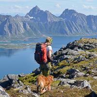
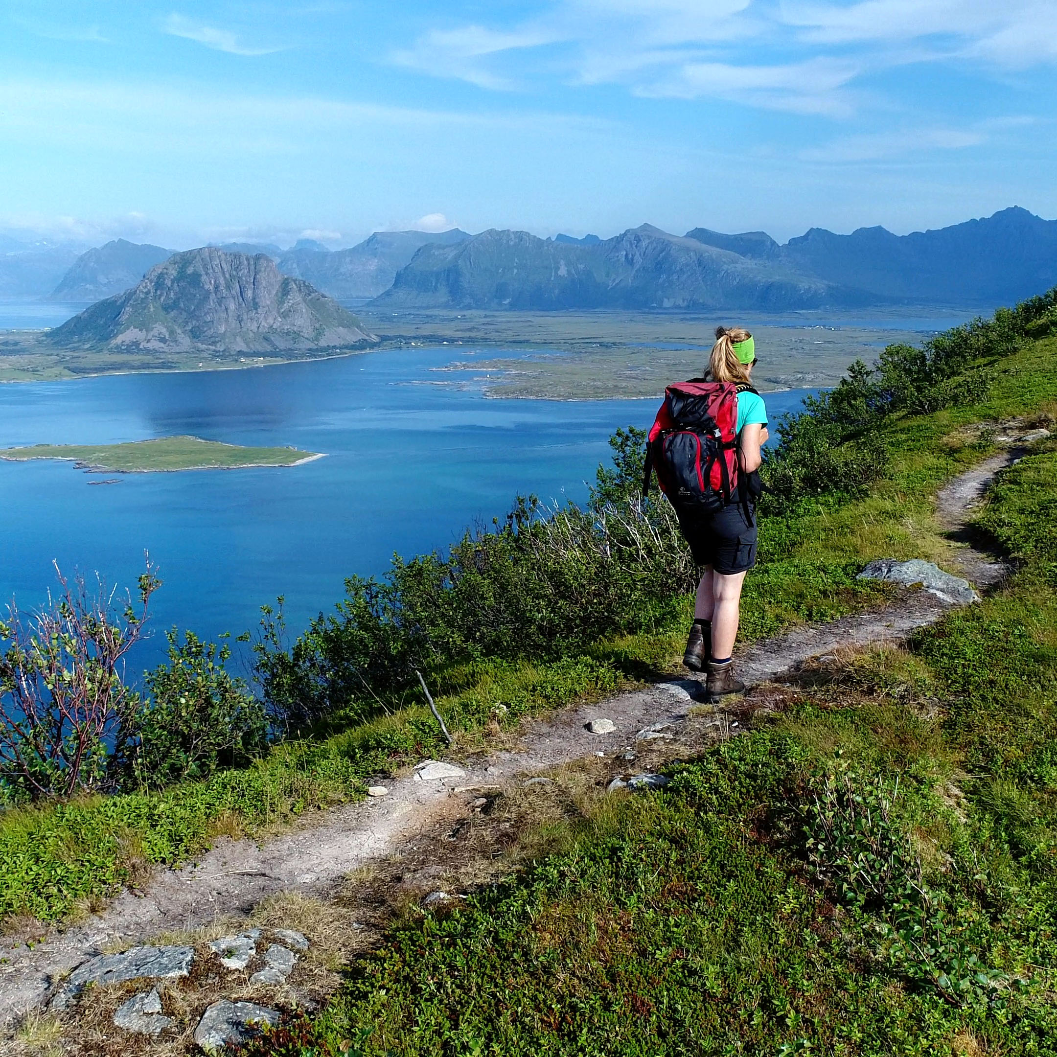
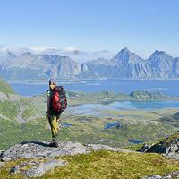
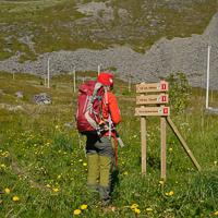
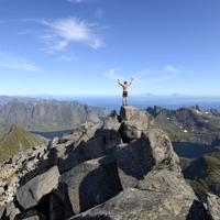
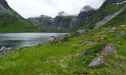
This summit on Vestvågøya Island is rarely visited, but it has magnificent panoramas in store for anyone bold enough to climb it. No crush of hikers here in any season: only a tiny passage through thick, rich vegetation that will bring you to a high mountain pasture on a plateau—the last walk before the summit. The points of view are many and varied all along this wild and sometimes difficult itinerary. We’ve described it as a round trip but it is also possible to make a great loop around Lake Lyngedalsheia.
To get to the tiny trail that climbs the west slope of Lyngedalsheia through the forest, you’ll first have to reach the old farm at the end of the path that goes along the east bank of the lake. You can either reach this path by walking along E10 for a hundred yards or so, or by going along the northern tip of Lyngedalsvatnet Lake. To do the latter, you’ll have to cross the stream that flows from the lake by going over some rocks. At the end of the path, you come upon an old farmhouse. A very small trail starts behind it, cut into the woods and marked out from time to time by red plastic posts. You’ll have pay very close attention to follow these discreet markings without losing them, especially when the vegetation is high. After a rather steep climb up the undergrowth, you reach the Lyngedalsheia plateau, a vast bog covered by very low plants. From the plateau, you’ll have your first point of view over the north and Gimsøya Island. Cross the plateau to reach its eastern side. From there, you can walk due south toward the northwest ridge of the Håtinden summit. There is no real trail but you can see a few signs of passage (mostly sheep) on the eastern border of the plateau as well as on the ridge leading to the peak. A small passage lets you climb the ridge to the summit. Avoid the scree and other fallen stones covering the slopes of the mountain as much as possible, but sometimes you’ll have to use your hands to get through the rocky passages.
The summit gives you a fantastic panorama, particularly out toward Austvågøya Island and the wide arm of the sea that separates it from the island of Vestvågøya. From the summit, you can keep going toward the southeast and reach the southern ridge of the mountain in the direction of Litlhåtinden up to a small pass at an altitude of 450m (1,476 ft). The passage between the Håtinden summit and the pass gives you a series of fabulous, varied landscapes.
Go back the same way. Even if it seems tempting, it is a very bad idea to go down into the little valley to the right of the pass to reach Lake Lyngedalsvatnet: if you opt for this “solution”, the tree-covered part of the valley and the return by the right bank of the lake are totally off trail and you’ll spend much more time and energy than if you returned by the summit.
From the pass, it is possible to keep going toward Vikjorden, and then, in passing by Kitaksla (532 m / 1,745 ft), to reach the southern tip of Lake Lyngedalsvatnet. To do this, you have to go around the Vikjordtinden summit by the south, at an altitude of roughly 500 m (1,640 ft) and then take the passage by the Kitaksla ridge and reach the little trail toward Finnvollen one way or another. From there, after you cross a vast boggy plain, you can get to the left (west) bank of Lake Lyngedalsvatnet and walk back to your starting point.
Watch out! This latter option is really difficult: it has passages that are precipitous and others that are steeply banked. What’s more, you won’t find a trail there worthy of the name.
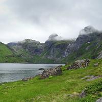
There’s a little trail that takes you from the electric power station of Forsfjord to the hamlet of Vindstad. This itinerary lets you avoid the very undependable ferry service that connected the two points (only on demand) until last year.
The trail is barely visible but won’t give you any major problems. It goes through two passages of big stone blocks and passes over a few rocky slabs where you’ll have to be careful, especially if you’re carrying a heavy pack. Finally, like many places in the Lofotens, the ground is partially covered by thick vegetation (ferns).
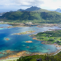
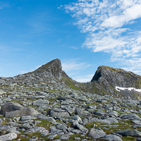
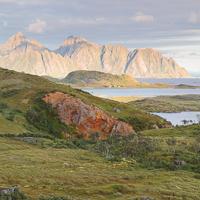
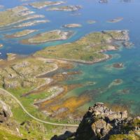
This mountain with its cut-off peak looks down on the bay of Skokkevika, its turquoise waters dotted with countless little islands. This is one of the most spectacular parts of Vestvågøya Island and even in all the Lofotens. It’s easy to get to the starting point of the hike along Route 815, it has superb viewpoints and a fairly easy trail to follow, yet few hikers come to this place.
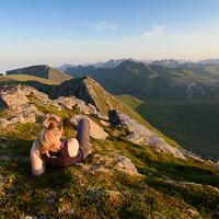
This summit overlooking the fjord of Skifiorden near Stamsund is still hardly known by hikers. There is no trail to reach it and the slopes are extremely steep. Despite these difficulties—surmountable for a hiker used to navigating this kind of terrain—the panoramas are impressive and varied all along the way.
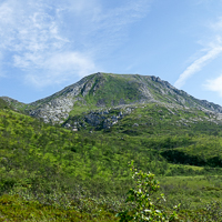
The Kroktinden summit, “the crooked summit” in Norwegian, looks like the tooth of a saw pointing to the sky. It’s a beautiful peak, relatively easy to reach, and offers a series of fantastic panoramas over the most mountainous island in the archipelago. Finally, not to diminish your pleasure in the slightest, a pretty little trail is visible all along the way and goes right to the summit.
Few hikers come here, although the summit is relatively easy to reach and looks down over the magnificent fjord of Austnes. You can admire varied landscapes of high pastures, lakes and mountains all along the way. If you want to walk far from crowds of tourists, while looking at one of the most beautiful summits Austvågøya Island, don’t miss this magnificent hike.
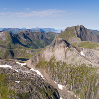
This summit, in the north of Vestvågøya Island, lets you discover a relatively unknown part of the archipelago. Three quarters of the ascent goes up a magnificent ridge line that gives this hike a very aerial look. Finally, the exceptional location of this summit gives it a unique panorama: it’s at the tip of a peninsula, facing the Norwegian Sea and with two big arms of the sea around it.
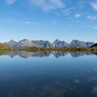
At the northwest tip of Vestvågøya Island, in a part of the archipelago that is still rarely visited, the discreet summit of Hellostinden holds pride of place. The walk to the top goes over relatively easy terrain through open landscapes. The panorama is magnificent from the summit, particularly the view of the Vågakallen massif on the neighboring island of Austvågøya. A hike for the whole family.
More information about this hike...
 You can read the detailed description of this hike (as well as 59 other hike descriptions), enjoy hundreds of photos, maps and practical information on the paper guidebook Hiking the LOFOTEN ISLANDS.
You'll find the guidebook on  , as well as at the following bookstores, for 24,07£ (not including shipping).
Order on Amazon
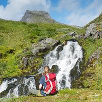
This hike is a real adventure that has lots of surprises for you! After a grueling start through rich vegetation on extremely steep slopes, you reach a peaceful valley with a succession of lakes and pastures, where half-wild sheep graze in season. The fine path you’ll find in the upper part of the valley was once used to construct a series of little dams and underground catchment areas that feed the electric power plant down below. Finally, despite the name Baken (which usually means a rounded hill in Norwegian), the summit is a real peak that gives you a striking view over this little-known part of the Lofotens.
More information about this hike...
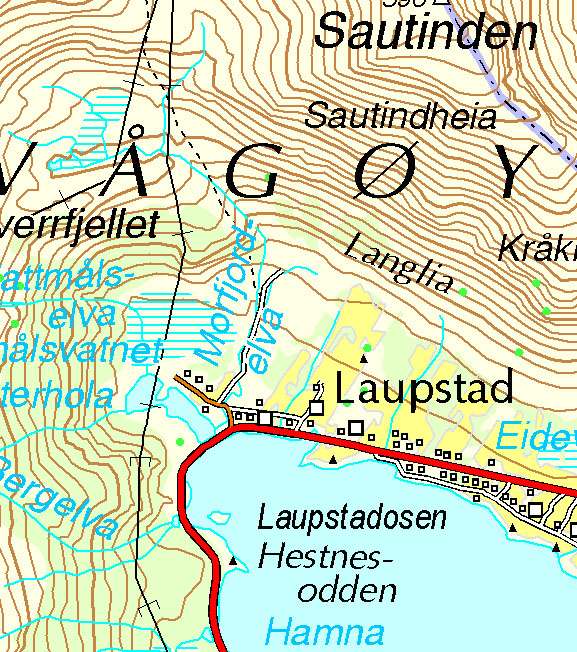
Sautinden and Bjørntinden
Pictures and track proposed by Halfdan Holm
These two peaks aren't among the most climbed in Lofoten, rather the contrary. No obvious path emerges from below, but climbing them is indeed possible, however only for experienced hikers.
The first leg of the trip follows a steep slope up 600m. One will then have to cross a somewhat steep and ravinated passage before getting up to the plateau with a beautiful view down to Flakstadpollen. The last leg up to Sautinden is a relatively easy hike. Getting from the plateau to Bjørntinden requires walking on some grassy slopes, where you wouldn’t want to slip. The last leg up to Bjørntinden is quite steep, and requires climbing with hands a couple of places. At the top you get a great view of the majestic Stjerntinden, the highest mountain on the Flakstadøy. You go back the same way, however getting directly down to Skjellfjorden from Bjørntinden may be possible, we don't know as there was zero visibility during our trip.
Pictures and track proposed by Halfdan Holm
This short, but somewhat intense hike takes you from Svolvær and straight up to an altitude of almost 600 m in about two hours. On the trip you get a great view of the famous Svolværgeita, a stop by the picture-worthy Djevelporten and then a fabulous view of East Lofoten from the top of Fløya. Though be advised: the very final part up to Fløya is only for experienced hikers, however the view a couple of meters further down is just as spectacular!
The first leg follows a clear path up a very steep hill. The walk is fun and a bit challenging, extra caution is required in wet weather. The path then flattens out and suddenly the challenge is mud rather than the steep climb. After passing Djevelporten the path follows the ridge towards the top of Fløya. At some points the path is somewhat unnecessarily close to the cliff, so walking a meter or two parallel to the path can be recommended here and there.
If you'd prefer not to climb up to the very top of Fløya, there's a path going southwest directly to a lower viewpoint, about 40 meters below the peak. If you decide to go all the way to the top you will be forced to climb using our hands in close proximity to the cliff. Climbing down the western ridge from Fløya is also a challenge, so going down to the other viewpoint via the northern ridge may be recommended.
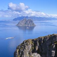
This long hike lets you get to the old village of Måstad in southeastern Værøy by traversing a large part of the island. It’s also the only way to get to the summits of Måhornet and Måstadheia, with their fantastic viewpoints over the open sea and their unique end-of-the-world atmosphere. The whole Måstad peninsula is classed as a natural park.
More information about this hike...
The summit of Håheia (438 m). is the second highest peak on the island of Værøy. It is also the only peak in the archipelago that has a road. It is private and leads to a NATO radar installation. Outside of this little bit of civilization, the wide open landscapes you’ll go through are magnificent. If the weather is clear at the top, you can admire the southeast of the Svartisen glacier, which is 120 km (75 mi). away on the Norwegian continent. This hike is easy and accessible to all. If you have time, you can extend it a little, to the summit of Hornet.
More information about this hike...
This big bay, which stretches out on a north-south axis, has a vast stony beach right under impressive granite cliffs. Between the beach and the cliffs there is extended an area of dunes, covered by a meadow with very low vegetation. Traces of human inhabitants from the stone age to the Middle Ages have been found on the southern part of the beach (Hagsletta). More recently the area around the bay was used as a sheep pasture until the 1960’s. The spot is both wild and easy to get to.
More information about this hike...
Not only is the summit of Nordlandsnupen the highest point on Værøy Island, but we think it’s the most beautiful. This relatively easy hike will quickly take you to an altitude high enough to give you magnificent views over the island of Mosken as well as over the whole southern tip of Moskenesøya Island. If you only have one day on Værøy and the sky is clear, go for it!
More information about this hike...
Hiking to Segltinden
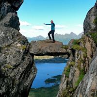
This magnificent peak stands like a shark’s fin above Kjerkfjorden (the central branch of Reinefjord). Even though it may be surrounded by sheer cliffs that appear inaccessible to hikers, there is nevertheless an approach from Kjerkfjorden. The view from the summit is just as breathtaking as the route that leads to it. It is not as much a traditional hike as a mountain race where you will often have to use your arms and legs to pull yourself up and climb.
In order to start the climb you first have to reach the hamlet of Kerkfjorden, which is possible either by taking the small boat from Reine, or on foot from Selfjord (see hike to Selfjord-Kjerkfjorden). Once at Kjerkfjord take the path through the village heading towards Austerdalen (east). At the end of the path begins the trail, which runs alongside a few chalets and climbs Austerdalen Valley following the stream. Just before the pass at GPS point N67 59.843 E13 02.663, leave the trail and turn right. If you glance at the steep mountain slope in front of you will see a “crack” in the slope running from west to east that meets up with a small pass (you can’t really see it from below but it is shown on the map just below point 475). In order to reach the place where the crack starts in the mountain (GPS N67 59.770 E13 02.739 – 325m altitude) you need to find your way amidst the rock formations and steep areas of slippery grass. Once you have found the start of the crack, you “merely” have to climb, using your arms and legs, the remaining 130m of steep slope up to the little pass. At the pass turn right (southwards) and follow the ridge via Målheia hill then climb the enormous bank opposite. At the top of the bank (approximately 685m) you climb down a little to a narrow pass (GPS N67 59.268 E13 02.835) which is the second difficult section of this route. The route over this pass is narrow and you need a good head for heights. On the other side of the pass, follow a faint path that runs to the right below the ridge for roughly 70m, then turn left (point GPS N67 59.226 E13 02.791 – altitude 705m) to the ridge. In order to reach the ridge you have to climb a rock that has been sculpted by erosion and that vaguely resembles a pile of pancakes. Once at the ridge all your efforts will be worthwhile and you just have to walk 250m on a small plateau with a lunar surface to the summit located just above a large cairn. Go back down exactly the same way. The use of a GPS is highly recommended, particularly to find certain passages near the crack...
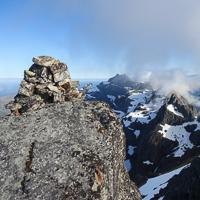
As the highest peak on the island of Moskenesøya, Hermannsdalstinden attracts certain hikers who want to be able to say they have conquered this Norwegian Everest. Aside from this rather meaningless “altitude record”, the hike itself, although certainly long, is fairly accessible and passes through absolutely magnificent alpine landscapes. The view from the top on a clear day is breathtaking!
More information about this hike...
This good 17 km hike takes you from the bay of Malnesvika as far as the fjord of Rolvsfjorden. The route passes through mountain and valley landscapes where the only living things are a few sheep. The more rounded mountains, unspoilt valleys and plateaus covered with peatland make this little-known and still rarely visited part of the island of Vestvågøya worth the detour.
More information about this hike...
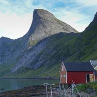
This impressive peak overlooks the tiny hamlet of Vikjorden. Looking up at it, the peak looks completely inaccessible, but there is in fact a very safe path to the top from where the view is absolutely fabulous!
More information about this hike...
A good hike that will take you, ridge after ridge, through the open, maritime landscapes of this part of the large island of Vestvågøya. On the way back you walk through an unspoilt valley the length of three mountain lakes where the only noise is the occasional trout jumping…
More information about this hike...

")